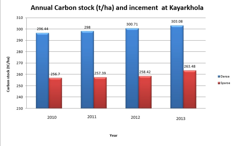
Biophysical (Forest carbon) data of Community forest in Kayar Khola watershed, Nepal under a Pilot project “Design and setting up of a governance and payment system for Nepal’s Community Forest Manag..
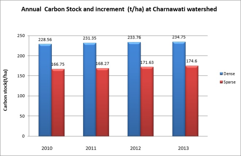
Biophysical (Forest carbon) data of Community forest in Charnawati watershed, Nepal under “Design and setting up of a governance and payment system for Nepal’s Community Forest Management under Reduc..
This checklist contains a total of 422 species of medicinal plants documented from Nepal part of the Kailash Sacred Landscape. This information has been collated from feasibility assessment report o..
This checklist contains a total of 143 species of medicinal plants documented from the India part of Kailash Sacred Landscape. This information has been collated from feasibility assessment report of..
This checklist contains a total of 75 species of medicinal plants documented from the China part of Kailash Sacred Landscape. This information has been collated from feasibility assessment report of ..
This checklist contains a total of 82 mammal species documented from Nepal part of the Kailash Sacred Landscape. This information has been collated from feasibility assessment report of the Kailash ..
This checklist contains a total of 38 mammal species documented from the India part of Kailash Sacred Landscape. This information has been collated from feasibility assessment report of the Kailash S..
This checklist contains a total of 8 mammal species documented from the China part of Kailash Sacred Landscape. This information has been collated from feasibility assessment report of the Kailash Sa..
This checklist contains a total of 470 bird species documented from Nepal part of the Kailash Sacred Landscape. This information has been collated from feasibility assessment report of the Kailash S..
This checklist contains a total of 191 bird species documented from the India part of Kailash Sacred Landscape. This information has been collated from feasibility assessment report of the Kailash Sa..