'%3e%3cg%3e%3cpath%20fill='%23036cb6'%20d='M0%200h134v33H0z'/%3e%3c/g%3e%3c/g%3e%3c/g%3e%3c/g%3e%3c/g%3e%3c/svg%3e)
Regional Database System
Discover and access datasets from the Hindu Kush Himalaya region
Thematic Topics
Featured Datasets
'%20stroke-width='2.418'%20d='M0-1.209h553.581'%20transform='scale(1%20-1)%20rotate(45%201163.11%2091.165)'/%3e%3cpath%20stroke='url(%23b)'%20stroke-width='2.418'%20d='M404.846%20598.671h391.726'/%3e%3cpath%20stroke='url(%23c)'%20stroke-width='2.418'%20d='M599.5%20795.742V404.017'/%3e%3cpath%20stroke='url(%23d)'%20stroke-width='2.418'%20d='m795.717%20796.597-391.441-391.44'/%3e%3cpath%20fill='%23fff'%20d='M600.709%20656.704c-31.384%200-56.825-25.441-56.825-56.824%200-31.384%2025.441-56.825%2056.825-56.825%2031.383%200%2056.824%2025.441%2056.824%2056.825%200%2031.383-25.441%2056.824-56.824%2056.824Z'/%3e%3cg%20clip-path='url(%23e)'%3e%3cpath%20fill='%23666'%20fill-rule='evenodd'%20d='M616.426%20586.58h-31.434v16.176l3.553-3.554.531-.531h9.068l.074-.074%208.463-8.463h2.565l7.18%207.181V586.58Zm-15.715%2014.654%203.698%203.699%201.283%201.282-2.565%202.565-1.282-1.283-5.2-5.199h-6.066l-5.514%205.514-.073.073v2.876a2.418%202.418%200%200%200%202.418%202.418h26.598a2.418%202.418%200%200%200%202.418-2.418v-8.317l-8.463-8.463-7.181%207.181-.071.072Zm-19.347%205.442v4.085a6.045%206.045%200%200%200%206.046%206.045h26.598a6.044%206.044%200%200%200%206.045-6.045v-7.108l1.356-1.355-1.282-1.283-.074-.073v-17.989h-38.689v23.43l-.146.146.146.147Z'%20clip-rule='evenodd'/%3e%3c/g%3e%3cpath%20stroke='%23C9C9C9'%20stroke-width='2.418'%20d='M600.709%20656.704c-31.384%200-56.825-25.441-56.825-56.824%200-31.384%2025.441-56.825%2056.825-56.825%2031.383%200%2056.824%2025.441%2056.824%2056.825%200%2031.383-25.441%2056.824-56.824%2056.824Z'/%3e%3c/g%3e%3cdefs%3e%3clinearGradient%20id='a'%20x1='554.061'%20x2='-.48'%20y1='.083'%20y2='.087'%20gradientUnits='userSpaceOnUse'%3e%3cstop%20stop-color='%23C9C9C9'%20stop-opacity='0'/%3e%3cstop%20offset='.208'%20stop-color='%23C9C9C9'/%3e%3cstop%20offset='.792'%20stop-color='%23C9C9C9'/%3e%3cstop%20offset='1'%20stop-color='%23C9C9C9'%20stop-opacity='0'/%3e%3c/linearGradient%3e%3clinearGradient%20id='b'%20x1='796.912'%20x2='404.507'%20y1='599.963'%20y2='599.965'%20gradientUnits='userSpaceOnUse'%3e%3cstop%20stop-color='%23C9C9C9'%20stop-opacity='0'/%3e%3cstop%20offset='.208'%20stop-color='%23C9C9C9'/%3e%3cstop%20offset='.792'%20stop-color='%23C9C9C9'/%3e%3cstop%20offset='1'%20stop-color='%23C9C9C9'%20stop-opacity='0'/%3e%3c/linearGradient%3e%3clinearGradient%20id='c'%20x1='600.792'%20x2='600.794'%20y1='403.677'%20y2='796.082'%20gradientUnits='userSpaceOnUse'%3e%3cstop%20stop-color='%23C9C9C9'%20stop-opacity='0'/%3e%3cstop%20offset='.208'%20stop-color='%23C9C9C9'/%3e%3cstop%20offset='.792'%20stop-color='%23C9C9C9'/%3e%3cstop%20offset='1'%20stop-color='%23C9C9C9'%20stop-opacity='0'/%3e%3c/linearGradient%3e%3clinearGradient%20id='d'%20x1='404.85'%20x2='796.972'%20y1='403.903'%20y2='796.02'%20gradientUnits='userSpaceOnUse'%3e%3cstop%20stop-color='%23C9C9C9'%20stop-opacity='0'/%3e%3cstop%20offset='.208'%20stop-color='%23C9C9C9'/%3e%3cstop%20offset='.792'%20stop-color='%23C9C9C9'/%3e%3cstop%20offset='1'%20stop-color='%23C9C9C9'%20stop-opacity='0'/%3e%3c/linearGradient%3e%3cclipPath%20id='e'%3e%3cpath%20fill='%23fff'%20d='M581.364%20580.535h38.689v38.689h-38.689z'/%3e%3c/clipPath%3e%3c/defs%3e%3c/svg%3e)
Popular Datasets
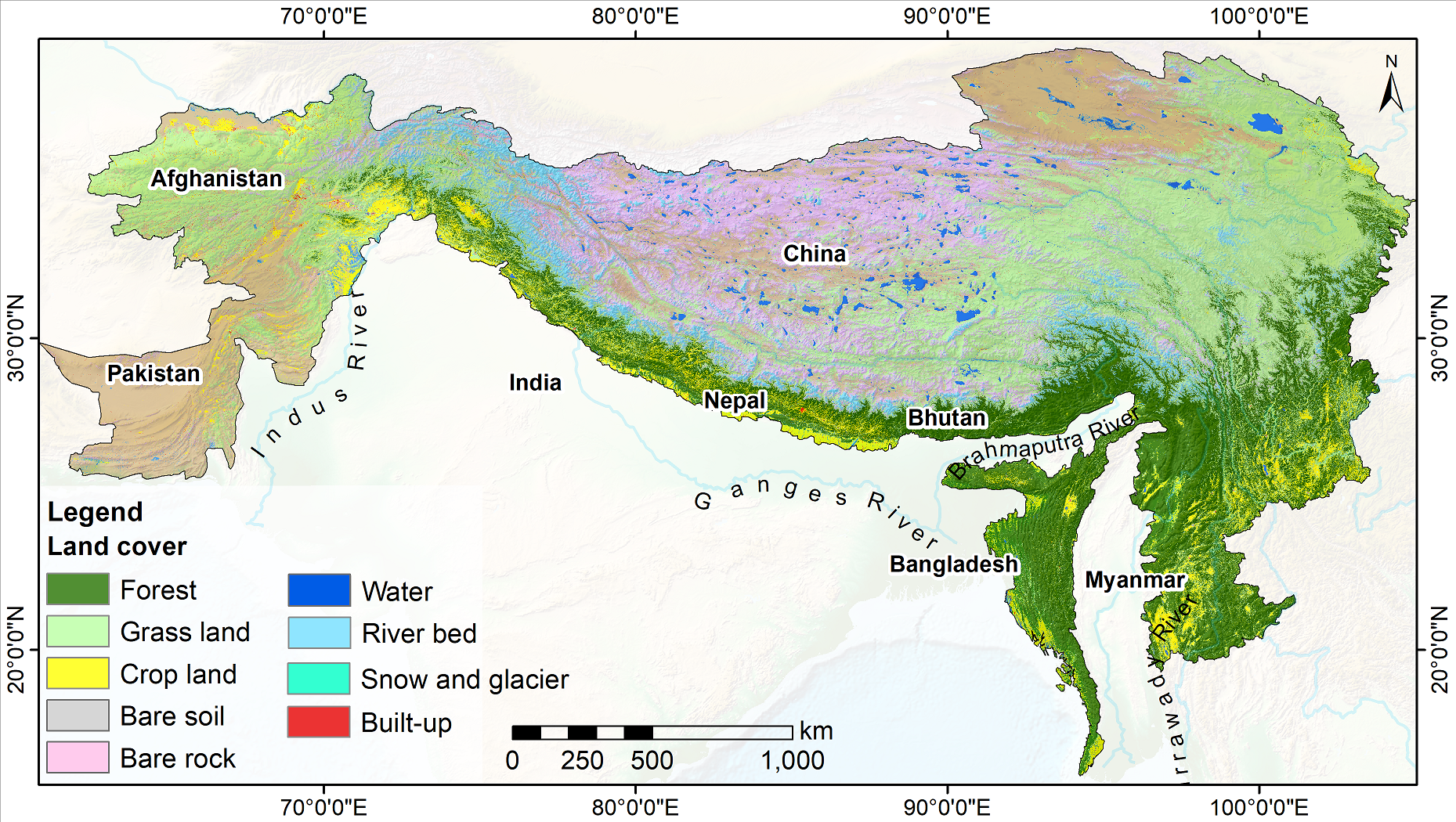
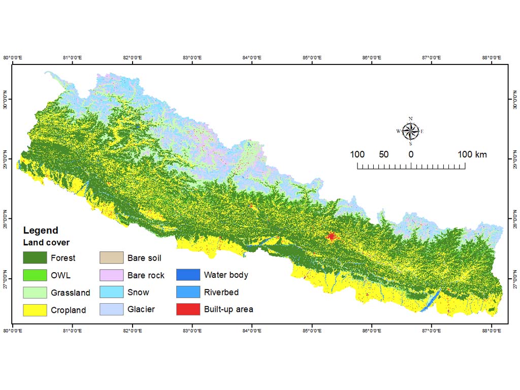
Land cover of HKH region
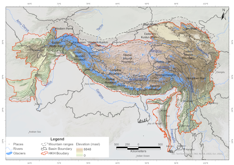
Land cover change is a significant contributor to environmental change. The degradation of forests and conversion of natural areas, forests, and farmlands to other land use impact ecosystem services and biodiversity significantly. Using multiple methodologies and input data sources, national agencies in different countries of the Hindu Kush Himalayan region have conducted land cover mapping at various times. Due to the differences in classification schema, methodologies, and input data sources used, currently available land cover data is not suitable for analysis of land cover changes over time. ICIMOD collaborated with SERVIR-Mekong at Asian Disaster Preparedness Center (ADPC), Afghanistan’s Ministry of Agriculture, Irrigation and Livestock, Bangladesh’s Forest Department, Nepal’s Forest Research and Training Centre, Myanmar’s Forest Department, SilvaCarbon, the Global Land Analysis and Discovery (GLAD) laboratory at the University of Maryland, and the United States Forest Services to develop the Regional Land Cover Monitoring System (RLCMS) for the HKH region. The system uses state-of-the-art remote sensing science and technology on the Google Earth Engine, and a standard set of input data sources to regularly generate high-quality land cover data at the regional level for the HKH, and at national levels for Afghanistan, Bangladesh, Myanmar, and Nepal. In developing the RLCMS, ICIMOD focused on collaboration and co-development with partner organizations to define different land cover typologies/classes, collect reference data samples, and validate results. Land cover maps for the HKH region spanning 2000–2022 have been produced under its SERVIR–HKH Initiative.
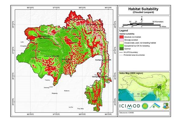
Habitat suitability data for the Clouded Leopard
The Hindu Kush Himalayan region (HKH) is an important biodiversity hotspot with more than 488 protected areas covering 39% of the region's geographical coverage. A majority of the protected areas are small and isolated and are not large enough to address conservation challenges. Only about 20% of the protected areas are transboundary in nature. There is limited data available on habitat suitability for conservation planning and landscape management in the Far Eastern Himalayan Landscape. A study carried out under the Landscape Initiative for Far Eastern Himalayas (HI-LIFE) Initiative at ICIMOD, estimates habitat suitability for the Clouded Leopard in the Far Eastern Himalayas using remote sensing and geographic information system tools, and available secondary information.
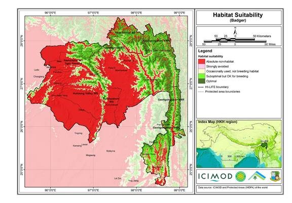
Habitat suitability data for the Badger
The Hindu Kush Himalayan region (HKH) is an important biodiversity hotspot with more than 488 protected areas covering 39% of the region's geographical coverage. A majority of the protected areas are small and isolated and are not large enough to address conservation challenges. Only about 20% of the protected areas are transboundary in nature. There is limited data available on habitat suitability for conservation planning and landscape management in the Far Eastern Himalayan Landscape. A study carried out under the Landscape Initiative for Far Eastern Himalayas (HI-LIFE) Initiative at ICIMOD, estimates habitat suitability for the Badger in the Far Eastern Himalayas using remote sensing and geographic information system tools, and available secondary information.