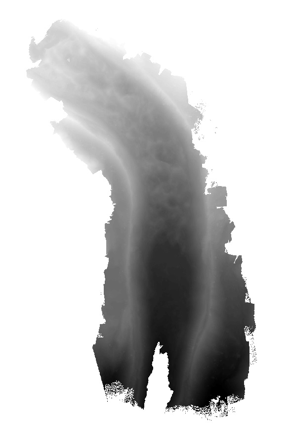
Elevation model of Lirung Glacier produced from unmanned aerial vehicle imagery using the Structure from Motion algorithm. The data is georeferenced using ground control points measured with differential GPS.
| Schema | iso19139 |
| Purpose | To study the behaviour of debris-covered glacier (surfaces) and related small scale processes with greater detail. |
| Descriptive Keyword | Debris cover, UAV, Unmanned Aerial Vehicle, Glacier (theme) Lirung (place) |
| Metadata Record Info | |
|---|---|
| Language | eng |
| Charset | utf8 |
| Hierarchy Level | dataset |
| Date | 2026-01-21T12:04:23 |
| Standard Name | North American Profile of ISO 19115:2003 |
| Contact | |||
|---|---|---|---|
| Name | Mr. Philip Kraaijenbrink, MSc | p.d.a.kraaijenbrink@uu.nl | |
| Organization Name | Utrecht University | Voice | |
| Position name | PhD Candidate | Address | |
| Role | author | ||
| Identification Info | |
|---|---|
| Title | Lirung UAV-derived elevation model, May 2013 |
| Date | 2016-06-02 |
| Date Type | publication |
| Abstract | Elevation model of Lirung Glacier produced from unmanned aerial vehicle imagery using the Structure from Motion algorithm. The data is georeferenced using ground control points measured with differential GPS. |
| Purpose | To study the behaviour of debris-covered glacier (surfaces) and related small scale processes with greater detail. |
| Status | completed |
| Charset | utf8 |
| Topic Category | environment |
| Spatial Representation Type | |
| Cited Responsible Parties | |||
|---|---|---|---|
| Name | Mr. Walter Immerzeel, PhD | w.w.immerzeel@uu.nl | |
| Organization Name | Utrecht University | Voice | 977-1-5275222 |
| Position name | Assistant Professor | Address | Netherlands |
| Role | originator | ||
| Geographic Extent | |||
|---|---|---|---|
| Geographic Extent East | 85.562 | Geographic Extent West | 85.562 |
| Geographic Extent North | 28.232 | Geographic Extent South | 28.232 |
| Resource Maintenance Information | |
|---|---|
| Maintenance and update frequency | unknown |
| User Defined Maintenance Frequency | |
| Date of Next Update | |
| Legal Constraints | |
|---|---|
| Use Limitation | Creative Commons Attribution 4.0 International (CC BY 4.0) |
| Use Limitation | Free to use with attribution to ICIMOD. |
| Access Constraints | license |
| Use Constraints | license |
| Reference System Information | |
|---|---|
| Code | WGS 1984 |
| Data Quality Info | |
|---|---|
| Hierarchy level | dataset |
| Distributor Info | |||
|---|---|---|---|
| metadata@icimod.org | Organization Name | ICIMOD | |
| Voice | Position name | ||
| Address | Role | distributor | |
| Transfer Option | |
|---|---|
| Online Resource | doi:10.3189/2016AoG71A072 |
| Online Resource | doi:10.1016/j.rse.2014.04.025 |