The land cover data for the years 1990 have been derived from Landsat TM 30m images using object based image analysis. The study estimated that 45.15% of Nepal is covered by forests and 25.41% by agriculture.
| Schema | iso19139 |
| Purpose | Development of baseline information for environmental management. |
| Descriptive Keyword | Land cover, Land use, servircat, icimod-servir (theme) Nepal (place) |
| Metadata Record Info | |
|---|---|
| Language | eng |
| Charset | utf8 |
| Hierarchy Level | dataset |
| Date | 2026-01-28T12:02:53 |
| Standard Name | North American Profile of ISO 19115:2003 |
| Contact | |||
|---|---|---|---|
| Name | Mr. Sameer Bajracharya | Sameer.Bajracharya@icimod.org | |
| Organization Name | ICIMOD, SERVIR Himalaya | Voice | |
| Position name | Research Associate GIS | Address | |
| Role | author | ||
| Identification Info | |
|---|---|
| Title | 
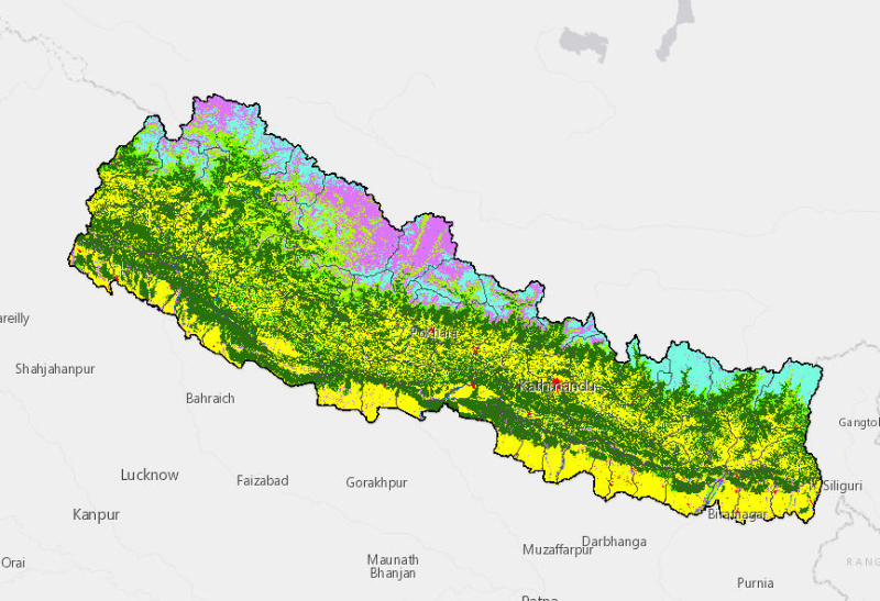
Land cover of Nepal 1990 |
| Date | 2014-10-31 |
| Date Type | publication |
| Abstract | The land cover data for the years 1990 have been derived from Landsat TM 30m images using object based image analysis. The study estimated that 45.15% of Nepal is covered by forests and 25.41% by agriculture. |
| Purpose | Development of baseline information for environmental management. |
| Status | completed |
| Charset | utf8 |
| Topic Category | geoscientificInformation |
| Spatial Representation Type | |
| Spatial Resolution | 30 |
| Cited Responsible Parties | |||
|---|---|---|---|
| Name | Mr. Kabir Uddin | Kabir.Uddin@icimod.org | |
| Organization Name | ICIMOD | Voice | 977-1-5275222 |
| Position name | GIS and Remote Sensing Analyst | Address | Nepal |
| Role | author | ||
| Geographic Extent | |||
|---|---|---|---|
| Geographic Extent East | 88.19456 | Geographic Extent West | 80.0522 |
| Geographic Extent North | 30.42472 | Geographic Extent South | 26.36836 |
| Resource Maintenance Information | |
|---|---|
| Maintenance and update frequency | asNeeded |
| User Defined Maintenance Frequency | |
| Date of Next Update | |
| Legal Constraints | |
|---|---|
| Use Limitation | Creative Commons Attribution 4.0 International (CC BY 4.0) |
| Access Constraints | license |
| Use Constraints | license |
| Reference System Information | |
|---|---|
| Code | WGS 1984 |
| Data Quality Info | |
|---|---|
| Hierarchy level | dataset |
| Distributor Info | |||
|---|---|---|---|
| metadata@icimod.org | Organization Name | ICIMOD | |
| Voice | Position name | ||
| Address | Role | distributor | |
| Transfer Option |
|---|