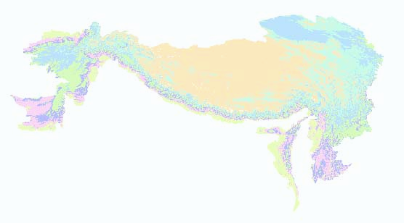
Digital polygon dataset of Elevation Zones of Hindu Kush Himalayan (HKH) Region. This dataset is derived from USGS, GTOPO30 (global digital elevation model, DEM) with has approximately 1 kilometer spatial resolution.
| Schema | iso19139 |
| Purpose | Topographic base data for general purpose |
| Descriptive Keyword | Elevation, Topography (theme) Hindu Kush Himalayan Region, HKH (place) |
| Metadata Record Info | |
|---|---|
| Language | eng |
| Charset | utf8 |
| Hierarchy Level | |
| Date | 2020-09-08T13:59:37 |
| Standard Name | ISO 19115:2003/19139 |
| Contact | |||
|---|---|---|---|
| Name | metadata@icimod.org | ||
| Organization Name | ICIMOD | Voice | 977-1-5275222 |
| Position name | Address | Khumaltar Lalitpur Kathmandu 3226 Nepal | |
| Role | pointOfContact | ||
| Identification Info | |
|---|---|
| Title | Elevation Zones of Hindu Kush Himalayan (HKH) Region |
| Date | 2007-09-20 |
| Date Type | publication |
| Abstract | Digital polygon dataset of Elevation Zones of Hindu Kush Himalayan (HKH) Region. This dataset is derived from USGS, GTOPO30 (global digital elevation model, DEM) with has approximately 1 kilometer spatial resolution. |
| Purpose | Topographic base data for general purpose |
| Status | completed |
| Charset | utf8 |
| Topic Category | elevation |
| Spatial Representation Type | vector |
| Equivalent Scale | 1000000 |
| Point Of Contact | |||
|---|---|---|---|
| Individual Name | metadata@icimod.org | ||
| Organization Name | ICIMOD | Voice | 977-1-5275222 |
| Position name | Address | Khumaltar Lalitpur Kathmandu 3226 Nepal | |
| Role | pointOfContact | ||
| Geographic Extent | |||
|---|---|---|---|
| Geographic Extent East | 105.044632 | Geographic Extent West | 60.853848 |
| Geographic Extent North | 39.318611 | Geographic Extent South | 15.9578 |
| Resource Maintenance Information | |
|---|---|
| Maintenance and update frequency | asNeeded |
| User Defined Maintenance Frequency | |
| Date of Next Update | |
| Legal Constraints | |
|---|---|
| Use Limitation | The content of this website can be accessed, printed and downloaded in an unaltered form (altered including being stretched, compressed, coloured or altered in any way so as to distort content from its original proportions or format) with copyright acknowledged, on a temporary basis for personal study that is not for a direct or indirect commercial use and any non-commercial use. Any content printed or downloaded may not be sold, licensed, transferred, copied or reproduced in whole or in part in any manner or in or on any media to any person without the prior written consent of the ICIMOD |
| Access Constraints | copyright |
| Use Constraints | otherRestrictions |
| Reference System Information | |
|---|---|
| Code | WGS 1984 |
| Data Quality Info | |
|---|---|
| Hierarchy level | dataset |
| Distributor Info | |||
|---|---|---|---|
| metadata@icimod.org | Organization Name | ICIMOD | |
| Voice | 977-1-5275222 | Position name | Sr. Cartographer/GIS Analyst |
| Address | Khumaltar Lalitpur Kathmandu 3226 Nepal | Role | distributor |