 Metadata Catalogue
environment
Type of resources
Available actions
Topics
Keywords
Contact for the resource
Provided by
Years
Representation types
Update frequencies
status
Scale
Resolution
-
Digital polygon data of Land use of Ludhi Khola Watershed, Gorkha, Nepal. This data is created using Topographic sheet data at scale of 25,000/50,000, of 1995 acquired from National Geographic Information Infrastructure Project (NGIIP), Dept. of Survey, Kathmandu, Nepal. The data was prepared for the Reducing Emission from Deforestation and Forest Degradation (REDD) Pilot Project. This is a joint project of ICIMOD with Asian Network for Sustainable Agriculture and Bio-resources (ANSAB) and Federation of Community for Forest Users of Nepal (FECOFUN) funded by NORAD.
-
Digital point data of Trees location in RDT Centre of Bhutan. This dataset is prepared by ICIMOD based on ground survey 2008.
-
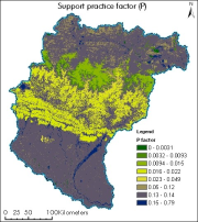
The dataset showing support practice factor of Koshi basin. It represents the soil conservation operations or other measures that control the erosion. It is measured as the ratio of soil loss with a specific support practice to the corresponding loss with ploughing up and down slope (Renard et al., 1997b; Prasannakumar et al., 2012).
-
Digital grid data of NDVI of September of Hindu Kush Himalayan (HKH) Region. This dataset is basic vector layer derived from ESRI Map & Data in 2001.
-
Digital grid data of NDVI of April of Hindu Kush Himalayan (HKH) Region. This dataset is basic vector layer derived from ESRI Map & Data in 2001.
-
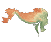
Digital polygon dataset of Major Habitat Areas of Afghanistan. This dataset is basic Vector layer acquired from ESRI Data and Maps 2001.
-
Surface Ozone data from Bode and Pakanajol of Kathmandu Valley.
-
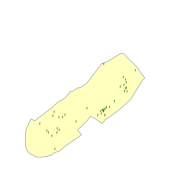
Digital polygon dataset of Land use of Sagarmatha National Park, Nepal. This dataset is created using Land use map created by Land Resources Mapping Project (LRMP) 1986.
-

Elevation model of Lirung Glacier produced from unmanned aerial vehicle imagery using the Structure from Motion algorithm. The data is georeferenced using ground control points measured with differential GPS.
-

Digital point data of Sample plots of Kayar Khola Watershed, Chitwan, Nepal. This dataset is created using Topographic sheet data at scale of 25,000/50,000, of 1995 acquired from National Geographic Information Infrastructure Project (NGIIP), Dept. of Survey, Kathmandu, Nepal. The data was prepared for the Reducing Emission from Deforestation and Forest Degradation (REDD) Pilot Project. This is a joint project of ICIMOD with Asian Network for Sustainable Agriculture and Bio-resources (ANSAB) and Federation of Community for Forest Users of Nepal (FECOFUN) funded by NORAD