 Metadata Catalogue
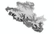
30 m
Type of resources
Available actions
Topics
Keywords
Contact for the resource
Provided by
Formats
Representation types
Update frequencies
status
Scale
Resolution
-

Large landslide dams are one of the most disastrous natural phenomena in mountainous regions all over the world Such dams are formed most commonly in tectonically active settings where high mountains border narrow and steep valleys and earthquakes occur frequently. Landslide dams are very diverse in terms of their formation, geotechnical characteristics, longevity, stability, and flood hazard. The two major causes of landslide dam formation are precipitation and earthquake. About 50% of dam-forming landslides are brought about by rainstorms and snowmelts, 40% by earthquakes, and 10% by other factors Geometry of valley in relation to geometry and volume of debris and discharge of damming river are some of the factors which are responsible for the development of landslide dams. Schuster et al. (1998) mentioned four groups of governing factors responsible for the spatial distribution of landslide dams. They are i) seismic intensity, ii) slope gradient and topography, iii) lithology and weathering properties, and iv) soil moisture and groundwater content. Landslide dams are generated by various types of mass movements, which range from rock falls and rockslides in steep walled, narrow canyons to earth slumps in flat river lowlands. Managing landslide-dam hazards requires an understanding of the temporal and spatial scales on which such phenomena occur. Many previous works on landslide dams have been mainly descriptive in character, and have produced a multitude of documented case studies and inventories (e.g. Costa and Schuster, 1988; Costa and Schuster, 1991). More recent work is focused on quantitative methods of determining the post-formation development, in particular, the controls on dam longevity.
-
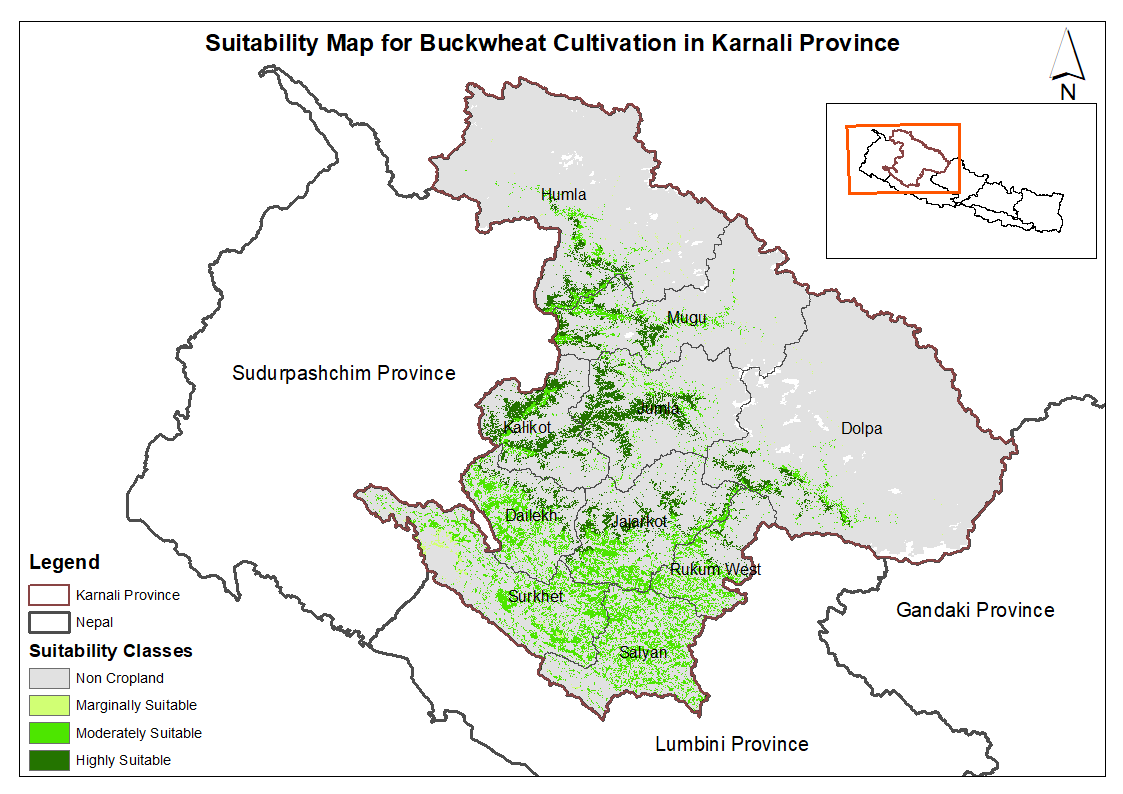
This dataset provides potential suitable area for cultivating buckwheat in the Karnali Province, Nepal. It is one of the datasets produced through a land suitability analysis conducted for high value agricultural commodities in the province. The suitability analysis was based on the FAO's' land suitability framework, which evaluates the suitability of land for cultivation of specific crop using climatic, topographic and soil characteristics. The analysis was conducted by ICIMOD under the Himalayan Resilience Enabling Action Programme (HI-REAP) project to support data-driven decision making and promote sustainable and climate-resilient agriculture in Karnali Province.
-

Digital dataset of Himalayan Ibex habitat area of Central Karakoram National Park (CKNP) area, Pakistan. This dataset is compiled through GPS based field survey conducted in year 2008 based on baseline study volume II, draft report, by Hagler Bailly (2005) and TJ Roberts. Habitat area is identified based on the GPS survey, baseline report and potential habitat area modeling using variables like land cover, slope, DEM etc through ENFA.
-
Digital dataset of Land Cover change between 1990 and 2000 of Central Karakoram National Park (CKNP) area, Pakistan. This dataset is derived from the LandSat satellite imagery of 1990 and 2000 to show the change in land cover classes.
-
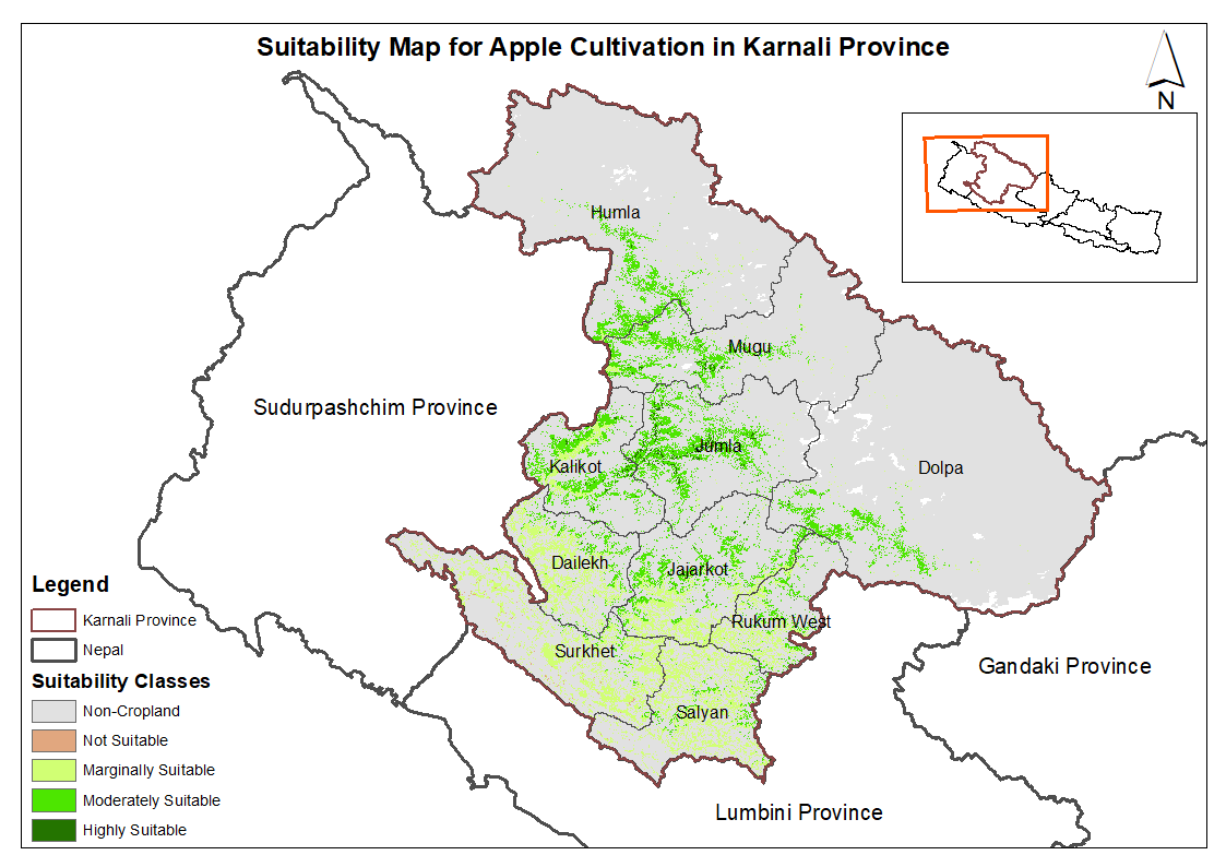
This dataset provides potential suitable area for cultivating apple in the Karnali Province, Nepal. It is one of the datasets produced through a land suitability analysis conducted for high value agricultural commodities in the province. The suitability analysis was based on the FAO's' land suitability framework, which evaluates the suitability of land for cultivation of specific crop using climatic, topographic and soil characteristics. The analysis was conducted by ICIMOD under the Himalayan Resilience Enabling Action Programme (HI-REAP) project to support data-driven decision making and promote sustainable and climate-resilient agriculture in Karnali Province.
-
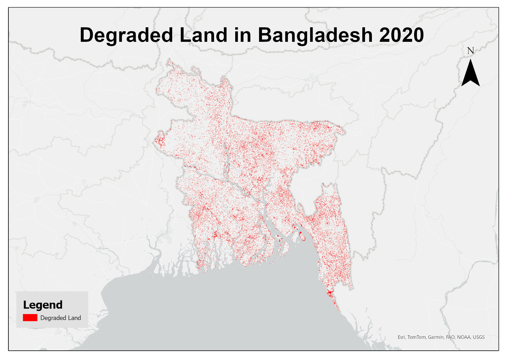
This dataset assesses land degradation in Bangladesh in 2020 based on SDG Indicator 15.3.1 by analyzing changes in land cover, land productivity, and soil organic carbon stocks. The 1OAO principle is applied in the computation method where changes in the sub-indicators are classified as improving, declining and stable. A land unit is considered degraded if any sub-indicator shows a negative or remains stable when previously degraded.
-
Digital dataset of Land Cover change between 2000 and 2010 of Central Karakoram National Park (CKNP) area, Pakistan. This dataset is derived from the LandSat satellite imagery of 2000 and 2010 to show the change in land cover classes.
-

The dataset compiles the grazing routes in the key grazing areas during spring, summer and autumn.
-

Large landslide dams are one of the most disastrous natural phenomena in mountainous regions all over the world Such dams are formed most commonly in tectonically active settings where high mountains border narrow and steep valleys and earthquakes occur frequently. Landslide dams are very diverse in terms of their formation, geotechnical characteristics, longevity, stability, and flood hazard. The two major causes of landslide dam formation are precipitation and earthquake. About 50% of dam-forming landslides are brought about by rainstorms and snowmelts, 40% by earthquakes, and 10% by other factors Geometry of valley in relation to geometry and volume of debris and discharge of damming river are some of the factors which are responsible for the development of landslide dams. Schuster et al. (1998) mentioned four groups of governing factors responsible for the spatial distribution of landslide dams. They are i) seismic intensity, ii) slope gradient and topography, iii) lithology and weathering properties, and iv) soil moisture and groundwater content. Landslide dams are generated by various types of mass movements, which range from rock falls and rockslides in steep walled, narrow canyons to earth slumps in flat river lowlands. Managing landslide-dam hazards requires an understanding of the temporal and spatial scales on which such phenomena occur. Many previous works on landslide dams have been mainly descriptive in character, and have produced a multitude of documented case studies and inventories (e.g. Costa and Schuster, 1988; Costa and Schuster, 1991). More recent work is focused on quantitative methods of determining the post-formation development, in particular, the controls on dam longevity.
-

Land cover data of Greater Chittagong, Bangladesh for 2010. This dataset is created using the LandSat 30 meter spatial resolution satellite image of 2000.