 Metadata Catalogue
Water bodies
Type of resources
Topics
Keywords
Contact for the resource
Provided by
Years
Representation types
Update frequencies
status
Scale
-
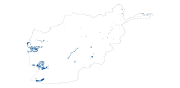
Digital polygon dataset of Lakes of Afghanistan. This dataset is created using 1:1,000,000 scale map of Afghanistan and derived from Afghanistan Information Management Systems (AIMS), Afghanistan.
-

Digital polygon dataset of Water bodies of Kathmandu Valley, Nepal. This dataset is created using Topographic sheet data at scale of 25,000/50,000, of 1995 acquired from National Geographic Information Infrastructure Project (NGIIP), Dept. of Survey Kathmandu, Nepal.
-
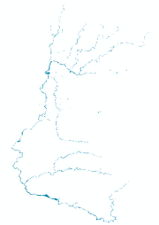
Digital polygon data of water areas location in Kathmandu valley, Nepal. This dataset is created using Topographic sheet data at scale of 25,000/50,000, of 1995 acquired from National Geographic Information Infrastructure Project (NGIIP), Dept. of Survey, Nepal and for emergency response planning in case of earthquake disaster.