 Metadata Catalogue
Soil Loss
Type of resources
Available actions
Topics
Keywords
Contact for the resource
Provided by
Representation types
Update frequencies
status
Scale
Resolution
-

Accelerated soil erosion is a common and environmentally destructive consequence of development in the populated trans-boundary Koshi river basin. The objective of this study was to assess assessment of soil erosion pattern and dynamic change trend of spatial distribution in erosion status between 1990 and 2010 and obtained the conservation priority map in the Koshi basin area using GIS and remote sensing. To develop soil erosion pattern revised universal soil loss equation (RUSLE) were adopted in ArcGIS environment where is the rainfall erosivity, soil erodibility, slope length factor, crop management factor and support practice factors were used a primary parameters. This study result the annual total erosion 4,35,996 ton/ha/yr in 2010.
-

Land cover change is a critical driver for enhancing the soil erosion risk in Nepal. Losing of the topsoil has a direct and indirect effect on human life and livelihoods. The present study provides an assessment of the decadal land use and land cover (LULC) change and consequent changes in the distribution of soil erosion risk for the year of 1990, 2000 and 2010 for the entire country of Nepal. The study attempted to understand how different land cover types change over the three decades and how it has changed the distribution of soil erosion risks in Nepal that would help in development of soil conservation priority. The land cover maps were produced using Geographic object-based image analysis (GEOBIA) using Landsat images. Soil erosion patterns were assessed using the revised universal soil loss equation (RUSLE) with the land cover as input. The study shows that the forest cover is the most dominant land cover in Nepal that comprises about 62 hundred thousand ha. The estimated annual erosion was 129.30 million tons in 1990 and 110.53 million tons in 2010. The assessment of soil erosion dynamics presented at the national, provincial and district level. District wise analysis revealed that Gulmi, Parbat, Syangja and Tanahu district required priority for soil conservation
-
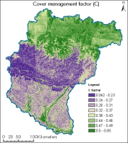
Digital grid dataset of cover management factor of Koshi basin. The dataset represents the protective coverage of canopy and organic material in direct contact with the ground. It is measured as the ratio of soil loss from land cropped under specific conditions to the corresponding loss from tilled land under clean-tilled continuous fallow conditions (Renard et al., 1997b; Prasannakumar et al., 2012).
-

Land cover change is a critical driver for enhancing the soil erosion risk in Nepal. Losing of the topsoil has a direct and indirect effect on human life and livelihoods. The present study provides an assessment of the decadal land use and land cover (LULC) change and consequent changes in the distribution of soil erosion risk for the year of 1990, 2000 and 2010 for the entire country of Nepal. The study attempted to understand how different land cover types change over the three decades and how it has changed the distribution of soil erosion risks in Nepal that would help in development of soil conservation priority. The land cover maps were produced using Geographic object-based image analysis (GEOBIA) using Landsat images. Soil erosion patterns were assessed using the revised universal soil loss equation (RUSLE) with the land cover as input. The study shows that the forest cover is the most dominant land cover in Nepal that comprises about 62 hundred thousand ha. The estimated annual erosion was 129.30 million tons in 1990 and 110.53 million tons in 2010. The assessment of soil erosion dynamics presented at the national, provincial and district level. District wise analysis revealed that Gulmi, Parbat, Syangja and Tanahu district required priority for soil conservation