 Metadata Catalogue
Soil Erosion
Type of resources
Available actions
Topics
Keywords
Contact for the resource
Provided by
Representation types
Update frequencies
status
Scale
Resolution
-
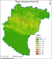
Digital grid dataset of Slope Steepness factor (S) of Koshi basin. It represents the effect of slope steepness on erosion. Soil loss increases more rapidly with slope steepness than it does with slope length. Slope steepness is derived from SRTM DEM 90 meter spatial resolution data.
-

Digital grid dataset of Slope length factor (S) of Koshi basin. It represents the slope length factor and the effect of slope length on erosion of Koshi basin. Slope length factor is derived from SRTM DEM 90 meter spatial resolution data
-

High levels of water-induced erosion in the transboundary Himalayan river basins are contributing to substantial changes in basin hydrology and inundation. Basin-wide information on erosion dynamics is needed for conservation planning, but field-based studies are limited. This study used remote sensing (RS) data and a geographic information system (GIS) to estimate the spatial distribution of soil erosion across the entire Koshi basin. The revised universal soil loss equation (RUSLE) was used in an ArcGIS environment with rainfall erosivity, soil erodibility, slope length and steepness, cover-management, and support practice factors as primary parameters. The estimated annual erosion from the basin was around 42 million tonnes.
-

Land cover change is a critical driver for enhancing the soil erosion risk in Nepal. Losing of the topsoil has a direct and indirect effect on human life and livelihoods. The present study provides an assessment of the decadal land use and land cover (LULC) change and consequent changes in the distribution of soil erosion risk for the year of 1990, 2000 and 2010 for the entire country of Nepal. The study attempted to understand how different land cover types change over the three decades and how it has changed the distribution of soil erosion risks in Nepal that would help in development of soil conservation priority. The land cover maps were produced using Geographic object-based image analysis (GEOBIA) using Landsat images. Soil erosion patterns were assessed using the revised universal soil loss equation (RUSLE) with the land cover as input. The study shows that the forest cover is the most dominant land cover in Nepal that comprises about 62 hundred thousand ha. The estimated annual erosion was 129.30 million tons in 1990 and 110.53 million tons in 2010. The assessment of soil erosion dynamics presented at the national, provincial and district level. District wise analysis revealed that Gulmi, Parbat, Syangja and Tanahu district required priority for soil conservation