 Metadata Catalogue
Society
Type of resources
Available actions
Topics
Keywords
Contact for the resource
Provided by
Years
Representation types
Update frequencies
status
Scale
-
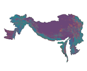
Digital polygon dataset of population density of Hindu Kush Himalayan (HKH) Region. This dataset is basic Vector layer acquired from USGS .
-

Digital point data of Urban Area at night in Hindu Kush Himalayan (HKH) Region. This dataset is basic Vector layer acquired from USGS in 1999.
-

Digital point data of Building footprints of Charnawati Watershed Dolakha, Nepal.This dataset is created using Topographic sheet data at scale of 25,000/50,000, of 1995 acquired from National Geographic Information Infrastructure Project (NGIIP), Dept. of Survey Kathmandu, Nepal. The data was prepared for the Reducing Emission from Deforestation and Forest Degradation (REDD) Pilot Project. This is a joint project of ICIMOD with Asian Network for Sustainable Agriculture and Bio-resources (ANSAB) and Federation of Community for Forest Users of Nepal (FECOFUN) funded by NORAD.
-
Digital point data of Settlement locations of Kayar Khola Watershed, Chitwan, Nepal. This dataset is created using Topographic sheet data at scale of 25,000/50,000, of 1995 acquired from National Geographic Information Infrastructure Project (NGIIP), Dept. of Survey, Kathmandu, Nepal. The data was prepared for the Reducing Emission from Deforestation and Forest Degradation (REDD) Pilot Project. This is a joint project of ICIMOD with Asian Network for Sustainable Agriculture and Bio-resources (ANSAB) and Federation of Community for Forest Users of Nepal (FECOFUN) funded by NORAD.
-
Digital point data of Settlement locations of Ludhi Khola Watershed, Gorkha, Nepal. This dataset is created using Topographic sheet data at scale of 25,000/50,000, of 1995 acquired from National Geographic Information Infrastructure Project (NGIIP), Dept. of Survey, Nepal and verified during 2010 field survey. The data was prepared for the Reducing Emission from Deforestation and Forest Degradation (REDD) Pilot Project. This is a joint project of ICIMOD with Asian Network for Sustainable Agriculture and Bio-resources (ANSAB) and Federation of Community for Forest Users of Nepal (FECOFUN) funded by NORAD.
-
Digital table data of Decadal Population Growth Estimates of Koshi Basin. This dataset is created using population census (2001 and 2011) at district level and comprise estimates at district, national and basin level.
-
Digital point dataset of Settlement Locations of Charnawati River Watershed, Dolakha, Nepal. This dataset is created using Topographic sheet data at scale of 25,000/50,000, of 1995 acquired from National Geographic Information Infrastructure Project (NGIIP), Dept. of Survey, Nepal. The data was prepared for the Reducing Emission from Deforestation and Forest Degradation (REDD) Pilot Project. This is a joint project of ICIMOD with Asian Network for Sustainable Agriculture and Bio-resources (ANSAB) and Federation of Community for Forest Users of Nepal (FECOFUN) funded by NORAD.
-
Digital table data of population and population density between 2001 and 2011 of Koshi Basin. This dataset is created using population census at district level and comprise demographic information of male, female and total population along with population density.
-
Digital table data of Socio-economic Characteristics of Koshi Basin. This dataset is created using population census at district level and comprise major socio-economic indicators captured in this sections are GDP per capita, poverty incidence, literacy ratio, economically active population, households access with basic amenities. Major data source for this dataset are Census of India(2011), census of Nepal (2011) and IMHE Technical Report(2013).