 Metadata Catalogue
Sagarmatha National Park, SNP
Type of resources
Topics
Keywords
Contact for the resource
Provided by
Representation types
Update frequencies
status
Scale
-

Digital point data of Telecommunication Facilities Location of Sagarmatha National Park, Nepal. This dataset is created using Topographic sheet data at scale of 25,000/50,000, of 1995 acquired from National Geographic Information Infrastructure Project (NGIIP), Dept. of Survey, Nepal.
-
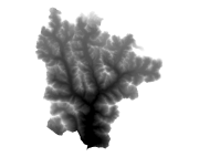
Digital Elevation Model, DEM of Sagarmatha National Park, Nepal. This dataset is DEM is created by interpolating contour and spot height using Topographic sheet data at scale of 25,000/50,000, of 1995 acquired from National Geographic Information Infrastructure Project (NGIIP), Dept. of Survey, Nepal.
-
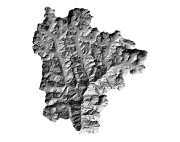
Digital grid data of Hill-shade of Sagarmatha National Park, Nepal. This dataset is derived from DEM created using Topographic sheet data at scale of 25,000/50,000, of 1995 acquired from National Geographic Information Infrastructure Project (NGIIP), Dept. of Survey, Kathmandu, Nepal.