 Metadata Catalogue
Road Network
Type of resources
Available actions
Topics
Keywords
Contact for the resource
Provided by
Representation types
Update frequencies
status
Scale
Resolution
-
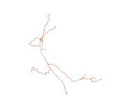
Digital line dataset of Road Network of Phobjikha Valley, Bhutan. This dataset is created using topographic sheet maps at scale of 50000 and prepared by ICIMOD.
-
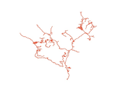
Digital polylines dataset of Road Network of Qomolangma Natural Preserve (QNP), Tibet, China.
-
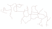
Digital line data of Road Network of Kayar Khola Watershed, Chitwan, Nepal. This dataset is created using Topographic sheet data at scale of 25,000/50,000, of 1995 acquired from National Geographic Information Infrastructure Project (NGIIP), Dept. of Survey, Kathmandu, Nepal. The data was prepared for the Reducing Emission from Deforestation and Forest Degradation (REDD) Pilot Project. This is a joint project of ICIMOD with Asian Network for Sustainable Agriculture and Bio-resources (ANSAB) and Federation of Community for Forest Users of Nepal (FECOFUN) funded by NORAD.
-
Digital line dataset of Road network of Wangchu, Bhutan. This dataset is created using topographic sheet maps at scale of 50000 and prepared by ICIMOD.
-
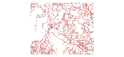
Road network data of East Rapti Watershed of road layer is generated by digitizing on Google Earth in order to develop an application for post flood response support.