 Metadata Catalogue
Rainfall
Type of resources
Available actions
Topics
Keywords
Contact for the resource
Provided by
Representation types
Update frequencies
status
Scale
-
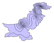
Digital polygon dataset of Average annual precipitation for Pakistan. The dataset is derived from Digital Chart of the world, DCW. The data layer is generated through interpolation of average monthly precipitation data from weather stations on a 30 arc-second resolution grid.
-
This Precipitation station shows the measurement of Rainfall at Tumlingtar, Nepal.
-
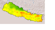
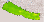
Monthly mean precipitation of June 2001 of Nepal. This dataset is created using actual averages precipitation using Win-surfer and GIS-arc/info software packages. The mean values were derived from daily precipitation readings.
-
This Precipitation station shows the measurement of Rainfall at Jiri, Nepal.
-
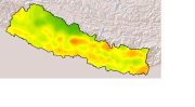
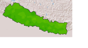
Monthly mean precipitation of September 2001 of Nepal. This dataset is created using actual averages precipitation using Win-surfer and GIS-arc/info software packages. The mean values were derived from daily precipitation readings.
-
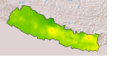
Monthly mean precipitation of Mayl 2001 of Nepal. This dataset is created using actual averages precipitation using Win-surfer and GIS-arc/info software packages. The mean values were derived from daily precipitation readings.
-
This Hydrological station shows the measurement of Water Level and Rainfall at Nowshera, Pakistan.
-
This Hydrological station shows the measurement of Water Level and Rainfall at Kalam, Pakistan.
-
Monthly mean precipitation of October 2001 of Nepal. This dataset is created using actual averages precipitation using Win-surfer and GIS-arc/info software packages. The mean values were derived from daily precipitation readings.
-
Monthly mean precipitation of November 2001 of Nepal. This dataset is created using actual averages precipitation using Win-surfer and GIS-arc/info software packages. The mean values were derived from daily precipitation readings.