 Metadata Catalogue
Population Distribution
Type of resources
Topics
Keywords
Contact for the resource
Provided by
Representation types
Update frequencies
status
Scale
-
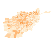
Digital polygon dataset of Population Distribution of 1998 per District of Afghanistan. This dataset is acquired from ESRI Map & Data 2001 and Afghanistan Information Management Systems (AIMS), Afghanistan.
-
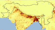
Digital Grid dataset of Population density estimates in 2005 for HKH region. This dataset is downloaded from the Center for International Earth Science Information Network (CIESIN), Columbia University. It shows the estimates of human population for the year 2005 by 2.5 arc-minute grid cells.
-
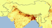
Digital Grid dataset of Population density estimates in 1995 in HKH region. This dataset is downloaded from the Center for International Earth Science Information Network (CIESIN), Columbia University. It shows the estimates of human population for the year 1995 by 2.5 arc-minute grid cells.
-
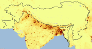
Digital Grid dataset of Population density estimates in 2015 for HKH region. This dataset is downloaded from the Center for International Earth Science Information Network (CIESIN), Columbia University. It shows the estimates of human population for the year 2015 by 2.5 arc-minute grid cells.