 Metadata Catalogue
Population
Type of resources
Topics
Keywords
Contact for the resource
Provided by
Representation types
Update frequencies
status
Scale
-
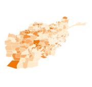
Digital polygon dataset of Population and Health Workers Ratio per District of Afghanistan. This dataset is acquired from ESRI Map & Data 2001 and Afghanistan Information Management Systems (AIMS), Afghanistan.
-
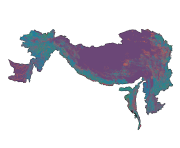
Digital polygon dataset of population density of Hindu Kush Himalayan (HKH) Region. This dataset is basic Vector layer acquired from USGS .
-
Hazard, vulnerability and risk due to flood are calculated at Village Development Committee (VDC) level of Nepal. Hazard index has been calculated as an arithmetic sum of flood frequency, height above nearest drainage (HAND), river density and forest density. Vulnerability index is the function of population as an Exposure, Sensitivity (sex ratio, dependency ratio and child women ratio) and Resilience (road density, population in abroad, literacy, transport facility, etc). Then risk is the sum of hazard and vulnerability index.