 Metadata Catalogue
Myanmar
Type of resources
Available actions
Topics
Keywords
Contact for the resource
Provided by
Representation types
Update frequencies
status
Scale
Resolution
-

Land cover data of Hindu Kush Himalayan region of Myanmar for 2010. This dataset is created using the LandSat 30 meter spatial resolution satellite image of 2010 and includes land cover information for Chin, Kachin, Rakhine and Shan states of Myanmar.
-
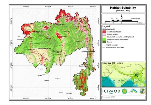
The Hindu Kush Himalayan region (HKH) is an important biodiversity hotspot with more than 488 protected areas covering 39% of the region's geographical coverage. A majority of the protected areas are small and isolated and are not large enough to address conservation challenges. Only about 20% of the protected areas are transboundary in nature. There is limited data available on habitat suitability for conservation planning and landscape management in the Far Eastern Himalayan Landscape. A study carried out under the Landscape Initiative for Far Eastern Himalayas (HI-LIFE) Initiative at ICIMOD, estimates habitat suitability for the Sambar deer in the Far Eastern Himalayas using remote sensing and geographic information system tools, and available secondary information.
-
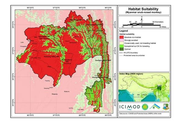
The Hindu Kush Himalayan region (HKH) is an important biodiversity hotspot with more than 488 protected areas covering 39% of the region's geographical coverage. A majority of the protected areas are small and isolated and are not large enough to address conservation challenges. Only about 20% of the protected areas are transboundary in nature. There is limited data available on habitat suitability for conservation planning and landscape management in the Far Eastern Himalayan Landscape. A study carried out under the Landscape Initiative for Far Eastern Himalayas (HI-LIFE) Initiative at ICIMOD, estimates habitat suitability for the Myanmar snubnosed monkey in the Far Eastern Himalayas using remote sensing and geographic information system tools, and available secondary information.
-
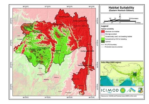
The Hindu Kush Himalayan region (HKH) is an important biodiversity hotspot with more than 488 protected areas covering 39% of the region's geographical coverage. A majority of the protected areas are small and isolated and are not large enough to address conservation challenges. Only about 20% of the protected areas are transboundary in nature. There is limited data available on habitat suitability for conservation planning and landscape management in the Far Eastern Himalayan Landscape. A study carried out under the Landscape Initiative for Far Eastern Himalayas (HI-LIFE) Initiative at ICIMOD, estimates habitat suitability for the Eastern hoolock gibbon in the Far Eastern Himalayas using remote sensing and geographic information system tools, and available secondary information.
-
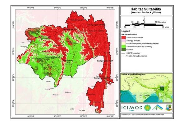
The Hindu Kush Himalayan region (HKH) is an important biodiversity hotspot with more than 488 protected areas covering 39% of the region's geographical coverage. A majority of the protected areas are small and isolated and are not large enough to address conservation challenges. Only about 20% of the protected areas are transboundary in nature. There is limited data available on habitat suitability for conservation planning and landscape management in the Far Eastern Himalayan Landscape. A study carried out under the Landscape Initiative for Far Eastern Himalayas (HI-LIFE) Initiative at ICIMOD, estimates habitat suitability for the Western hoolock gibbon in the Far Eastern Himalayas using remote sensing and geographic information system tools, and available secondary information.
-

A land cover change is a significant contributor to environmental change. Comparable, harmonized and standardized land cover data at different dates are required to assess the land cover change. In this regard, regional land cover data of Eastern Himalayas for 2000 was developed by the International Centre for Integrated Mountain Development (ICIMOD) using Landsat TM images of 2000.
-

A land cover change is a significant contributor to environmental change. Comparable, harmonized and standardized land cover data at different dates are required to assess the land cover change. In this regard, regional land cover data of Eastern Himalayas for 1975 was developed by the International Centre for Integrated Mountain Development (ICIMOD) using Landsat MSS images of 1975.
-
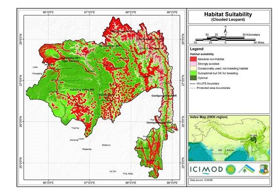
The Hindu Kush Himalayan region (HKH) is an important biodiversity hotspot with more than 488 protected areas covering 39% of the region's geographical coverage. A majority of the protected areas are small and isolated and are not large enough to address conservation challenges. Only about 20% of the protected areas are transboundary in nature. There is limited data available on habitat suitability for conservation planning and landscape management in the Far Eastern Himalayan Landscape. A study carried out under the Landscape Initiative for Far Eastern Himalayas (HI-LIFE) Initiative at ICIMOD, estimates habitat suitability for the Clouded Leopard in the Far Eastern Himalayas using remote sensing and geographic information system tools, and available secondary information.
-
The Poverty and Vulnerability Assessment (PVA) dataset was developed to capture the micro-level perspective of people's experiences with poverty and vulnerability and to monitor poverty and vulnerability trends on the ground. The assessment was based on a standardized questionnaire that has been developed to assess, describe, and analyse the situation of poor and vulnerable people in the HKH region. This will lead to an enhanced understanding of multiple aspects of livelihood assets, structures, and the processes that underpin such assets. It will also help determine levels of access, terms of exchange, and returns from livelihood assets as well as livelihood strategies and their outcomes for the poor.
-

The Hindu Kush Himalayan region (HKH) is an important biodiversity hotspot with more than 488 protected areas covering 39% of the region's geographical coverage. A majority of the protected areas are small and isolated and are not large enough to address conservation challenges. Only about 20% of the protected areas are transboundary in nature. There is limited data available on habitat suitability for conservation planning and landscape management in the Far Eastern Himalayan Landscape. A study carried out under the Landscape Initiative for Far Eastern Himalayas (HI-LIFE) Initiative at ICIMOD, estimates habitat suitability for the Himalayan black bear in the Far Eastern Himalayas using remote sensing and geographic information system tools, and available secondary information.