 Metadata Catalogue
Landsat
Type of resources
Topics
Keywords
Contact for the resource
Provided by
Representation types
Update frequencies
status
Scale
Resolution
-

The past few decades have seen high levels of deforestation and forest degradation in the Hindu Kush Himalayan (HKH) region. In this context, under SERVIR Himalaya programme, ICIMOD has developed forest cover monitoring system to identify forest change hotspot areas which need critical forest management attention in four pilot areas. This forest cover data of Bandarban, Bangladesh for 2014 has been developed using LandSat 8 data in a semi-automated manner as part of the forest cover monitoring system.
-

Land cover change is a critical driver for enhancing the soil erosion risk in Nepal. Losing of the topsoil has a direct and indirect effect on human life and livelihoods. The present study provides an assessment of the decadal land use and land cover (LULC) change and consequent changes in the distribution of soil erosion risk for the year of 1990, 2000 and 2010 for the entire country of Nepal. The study attempted to understand how different land cover types change over the three decades and how it has changed the distribution of soil erosion risks in Nepal that would help in development of soil conservation priority. The land cover maps were produced using Geographic object-based image analysis (GEOBIA) using Landsat images. Soil erosion patterns were assessed using the revised universal soil loss equation (RUSLE) with the land cover as input. The study shows that the forest cover is the most dominant land cover in Nepal that comprises about 62 hundred thousand ha. The estimated annual erosion was 129.30 million tons in 1990 and 110.53 million tons in 2010. The assessment of soil erosion dynamics presented at the national, provincial and district level. District wise analysis revealed that Gulmi, Parbat, Syangja and Tanahu district required priority for soil conservation
-

The past few decades have seen high levels of deforestation and forest degradation in the Hindu Kush Himalayan (HKH) region. In this context, under SERVIR Himalaya programme, ICIMOD has developed forest cover monitoring system to identify forest change hotspot areas which need critical forest management attention in four pilot areas. This forest cover data of Bandarban, Bangladesh for 2013 has been developed using LandSat 8 data in a semi-automated manner as part of the forest cover monitoring system.
-

Land cover change is a critical driver for enhancing the soil erosion risk in Nepal. Losing of the topsoil has a direct and indirect effect on human life and livelihoods. The present study provides an assessment of the decadal land use and land cover (LULC) change and consequent changes in the distribution of soil erosion risk for the year of 1990, 2000 and 2010 for the entire country of Nepal. The study attempted to understand how different land cover types change over the three decades and how it has changed the distribution of soil erosion risks in Nepal that would help in development of soil conservation priority. The land cover maps were produced using Geographic object-based image analysis (GEOBIA) using Landsat images. Soil erosion patterns were assessed using the revised universal soil loss equation (RUSLE) with the land cover as input. The study shows that the forest cover is the most dominant land cover in Nepal that comprises about 62 hundred thousand ha. The estimated annual erosion was 129.30 million tons in 1990 and 110.53 million tons in 2010. The assessment of soil erosion dynamics presented at the national, provincial and district level. District wise analysis revealed that Gulmi, Parbat, Syangja and Tanahu district required priority for soil conservation
-
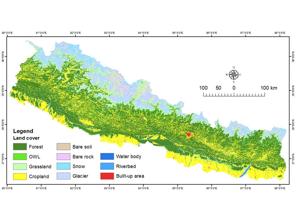
The annual land cover data of Nepal (2000-2022) have been created through the National Land Cover Monitoring System (NLCMS) for Nepal. The system uses freely available remote-sensing data (Landsat) and a cloud-based machine learning architecture in the Google Earth Engine (GEE) platform to generate land cover maps on an annual basis using a harmonized and consistent classification system. The NLCMS is developed by the Forest Research and Training Centre (FRTC), Ministry of Forests and Environment, Government of Nepal with support from the International Centre for Integrated Mountain Development (ICIMOD) through SERVIR Hindu Kush Himalaya (SERVIR-HKH), a joint initiative in partnership with the National Aeronautics and Space Administration (NASA) and the United States Agency for International Development (USAID). Collaborators include SERVIR–Mekong at the Asian Disaster Preparedness Center (ADPC), SilvaCarbon, Global Land Analysis and Discovery (GLAD) group at the University of Maryland, and the US Forest Service. The annual land cover data of Nepal for 2000-2019 was first published in 2022 while the data for 2020-2022 was released in 2024.
-

The annual land cover data of Afghanistan (2000-2018) have been created through the National Land Cover Monitoring System (NLCMS) for Afghanistan. The system uses freely available remote-sensing data (Landsat) and a cloud-based machine learning architecture in the Google Earth Engine (GEE) platform to generate land cover maps on an annual basis using a harmonized and consistent classification system. The NLCMS is developed by International Centre for Integrated Mountain Development (ICIMOD) together with Afghanistan’s Ministry of Agriculture, Irrigation and Livestock (MAIL) and National Statistic and Information Authority (NSIA). The NLCMS system is customized from the Regional Land Cover Monitoring System (RLCMS) which is a collaborative effort between SERVIR-HKH at ICIMOD and SERVIR-Mekong at the Asian Disaster Preparedness Center (ADPC), with co-development partners - the United States Forest Services (USFS), SilvaCarbon, and Global Land Analysis and Discovery (GLAD) group at the University of Maryland.
-
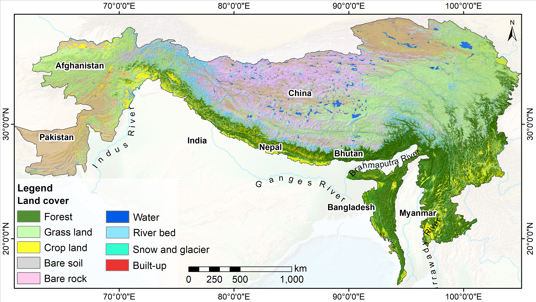
Land cover change is a significant contributor to environmental change. The degradation of forests and conversion of natural areas, forests, and farmlands to other land use impact ecosystem services and biodiversity significantly. Using multiple methodologies and input data sources, national agencies in different countries of the Hindu Kush Himalayan region have conducted land cover mapping at various times. Due to the differences in classification schema, methodologies, and input data sources used, currently available land cover data is not suitable for analysis of land cover changes over time. ICIMOD collaborated with SERVIR-Mekong at Asian Disaster Preparedness Center (ADPC), Afghanistan’s Ministry of Agriculture, Irrigation and Livestock, Bangladesh’s Forest Department, Nepal’s Forest Research and Training Centre, Myanmar’s Forest Department, SilvaCarbon, the Global Land Analysis and Discovery (GLAD) laboratory at the University of Maryland, and the United States Forest Services to develop the Regional Land Cover Monitoring System (RLCMS) for the HKH region. The system uses state-of-the-art remote sensing science and technology on the Google Earth Engine, and a standard set of input data sources to regularly generate high-quality land cover data at the regional level for the HKH, and at national levels for Afghanistan, Bangladesh, Myanmar, and Nepal. In developing the RLCMS, ICIMOD focused on collaboration and co-development with partner organizations to define different land cover typologies/classes, collect reference data samples, and validate results. Land cover maps for the HKH region spanning 2000–2022 have been produced under its SERVIR–HKH Initiative.