 Metadata Catalogue
Land Use
Type of resources
Topics
Keywords
Contact for the resource
Provided by
Representation types
Update frequencies
status
Scale
Resolution
-
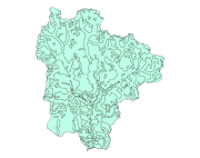
Digital polygon dataset of Land use of Sagarmatha National Park, Nepal. This dataset is created using Land use map created by Land Resources Mapping Project (LRMP) 1986.
-
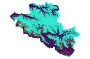
Digital dataset of Land Cover in 1990 of Central Karakoram National Park(CKNP) area, Pakistan. This dataset is extracted from LandSat satellite imagery of 2000 with spatial resolution of 30 m and spectral resolution of 6 bands. Land cover classes are classified using Nearest Neighbor method.
-
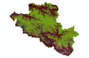
Digital dataset of Land Cover in 2000 of Central Karakoram National Park(CKNP) area, Pakistan. This dataset is extracted from LandSat satellite imagery of 2000 with spatial resolution of 30 m and spectral resolution of 6 bands. land cover classes are classified using Nearest Neighbor method.
-
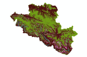
Digital dataset of Land Cover in 2010 of Central Karakoram National Park (CKNP) area, Pakistan. This dataset is extracted from LandSat satellite imagery of 2010 with spatial resolution of 30 m and spectral resolution of 6 bands. Land cover classes are classified using Nearest Neighbor method.