 Metadata Catalogue
Land Cover Classification
Type of resources
Available actions
Topics
Keywords
Contact for the resource
Provided by
Representation types
Update frequencies
status
Scale
Resolution
-

Land cover data of Hindu Kush Himalayan region of Myanmar for 2010. This dataset is created using the LandSat 30 meter spatial resolution satellite image of 2010 and includes land cover information for Chin, Kachin, Rakhine and Shan states of Myanmar.
-

Land cover data of Hindu Kush Himalayan region of Pakistan for 2010. This dataset is created using the LandSat 30 meter spatial resolution satellite image of 2010.
-

Land cover data of Greater Chittagong, Bangladesh for 1989. This dataset is created using the LandSat 30 meter spatial resolution satellite image of 1989.
-
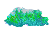
Land cover data of Bhutan for 2010. This dataset is created using the LandSat 30 meter spatial resolution satellite image of 2010.
-

Land cover data of Hindu Kush Himalayan region of Pakistan for 1990. This dataset is created using the LandSat 30 meter spatial resolution satellite image of 1990.
-

Digital dataset of Forest Cover of Central Karakoram National Park (CKNP) area, Pakistan. This dataset is extracted from land cover dataset of 2010.
-

Land cover data of Hindu Kush Himalayan region of Pakistan for 2000. This dataset is created using the LandSat 30 meter spatial resolution satellite image of 2000.
-

Land cover data of Greater Chittagong, Bangladesh for 2010. This dataset is created using the LandSat 30 meter spatial resolution satellite image of 2000.
-

Land cover data of Greater Chittagong, Bangladesh for 2010. This dataset is created using the LandSat 30 meter spatial resolution satellite image of 2010.