 Metadata Catalogue
Keyword
Land Cover
Type of resources
Topics
Keywords
Contact for the resource
Provided by
Representation types
Update frequencies
status
Scale
Resolution
From
1
-
3
/
3
-
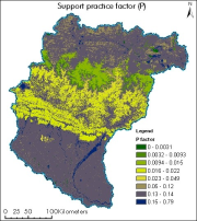
The dataset showing support practice factor of Koshi basin. It represents the soil conservation operations or other measures that control the erosion. It is measured as the ratio of soil loss with a specific support practice to the corresponding loss with ploughing up and down slope (Renard et al., 1997b; Prasannakumar et al., 2012).
-
Landcover is derived using Landsat of 2010.
-

This dataset shows the land cover of the Kangchenjunga Landscape in the year 2000.