 Metadata Catalogue
Koshi Basin
Type of resources
Available actions
Topics
Keywords
Contact for the resource
Provided by
Years
Representation types
Update frequencies
status
Scale
Resolution
-

Digital Elevation Model (DEM) of Koshi Basin compiled from global SRTM DEM of 90 m resolution.
-

Digital grid dataset of Slope length factor (S) of Koshi basin. It represents the slope length factor and the effect of slope length on erosion of Koshi basin. Slope length factor is derived from SRTM DEM 90 meter spatial resolution data
-
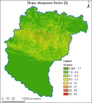
Digital grid dataset of Slope Steepness factor (S) of Koshi basin. It represents the effect of slope steepness on erosion. Soil loss increases more rapidly with slope steepness than it does with slope length. Slope steepness is derived from SRTM DEM 90 meter spatial resolution data.
-
Landslide susceptibility map of Koshi Basin is to identify landslide hazard areas for use during the planning of developmental activities.
-
Development Pressure Index (DPI): refers to the vulnerability due to the economic development activities in the basin. Parameters such as GDP growth, population growth, expansion of irrigated land, etc are accounted in this index.
-
Annual Mean Precipitation data for Caurikhark station, Koshi Basin, Nepal. This dataset is based on average daily precipitation reading which is accumulated for month and Accumulated monthly totals for the year.
-
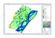
Digital dataset of Wetland ecosystem of Koshi Tappu Reserve within Koshi Basin. This dataset consist various vegetation cover/ land cover and water bodies for Koshi Tappu.
-
Landslide susceptibility map of Koshi Basin is to identify landslide hazard areas for use during the plnanning of developmental activities.
-
Landslide inventory is polygon of every landslide for landslide characterization and analsysis to understand landslide distribution pattern, and identify areas susceptible to landslide events in future. This is important for proper consideration of landuse codes for planning developmental activities.
-
Landslide susceptibility map of Koshi Basin is to identify landslide hazard areas for use during the plnanning of developmental activities.