 Metadata Catalogue
Kathmandu, Nepal
Type of resources
Topics
Keywords
Contact for the resource
Provided by
Representation types
Update frequencies
status
Scale
-

Bridge(polyline) dataset of Kathmandu Metropolitan City for the Geo-visualization on emergency response in case of earthquake disaster.
-

Parks(polygon) dataset of Kathmandu for the Geo-visualization on emergency response in case of earthquake disaster.
-
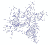
Sewerage line(polyline) dataset of Kathmandu Metropolitian City for the Geo-visualization on emergency response in case of earthquake disaster.
-
Place name(point) dataset of Kathmandu Metropolitian City for the Geo-visualization on emergency response in case of earthquake disaster.
-
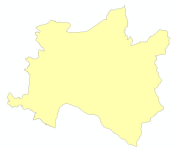
Boundary(polygon) dataset of Kathmandu Metropolitian City for the Geo-visualization on emergency response in case of earthquake disaster.
-
Electric line(polyline) dataset of Kathmandu Metropolitian City for the Geo-visualization on emergency response in case of earthquake disaster.
-
Sewerage manhole(point) dataset of Kathmandu Metropolitian City for the Geo-visualization on emergency response in case of earthquake disaster.
-

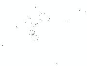
Factories(point) dataset of Kathmandu Municipality for the Geo-visualization on emergency response in case of earthquake disaster.
-

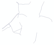
Stream(polyline) dataset of Kathmandu Metropolitian City for the Geo-visualization on emergency response in case of earthquake disaster.
-
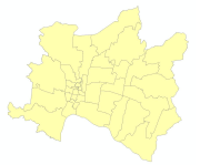
Ward boundary(polygon) dataset of Kathmandu Metropolitian City for the Geo-visualization on emergency response in case of earthquake disaster.