 Metadata Catalogue
Karnali
Type of resources
Topics
Keywords
Contact for the resource
Provided by
Formats
Representation types
Update frequencies
status
Scale
Resolution
-
This is the first inventory of glaciers of Nepal Himalaya. The data is prepared using topographic maps, aerial photographs and satellite images.
-
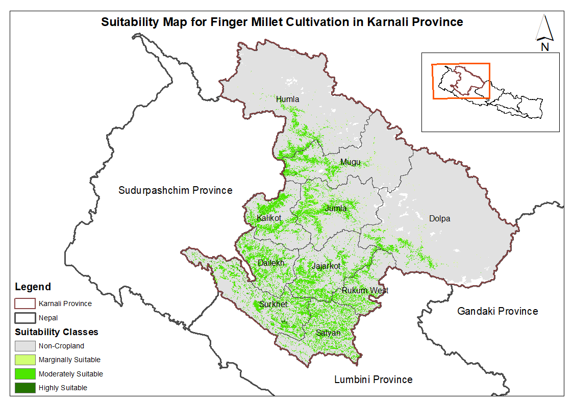
This dataset provides potential suitable area for cultivating finger millet in the Karnali Province, Nepal. It is one of the datasets produced through a land suitability analysis conducted for high value agricultural commodities in the province. The suitability analysis was based on the FAO's' land suitability framework, which evaluates the suitability of land for cultivation of specific crop using climatic, topographic and soil characteristics. The analysis was conducted by ICIMOD under the Himalayan Resilience Enabling Action Programme (HI-REAP) project to support data-driven decision making and promote sustainable and climate-resilient agriculture in Karnali Province.
-
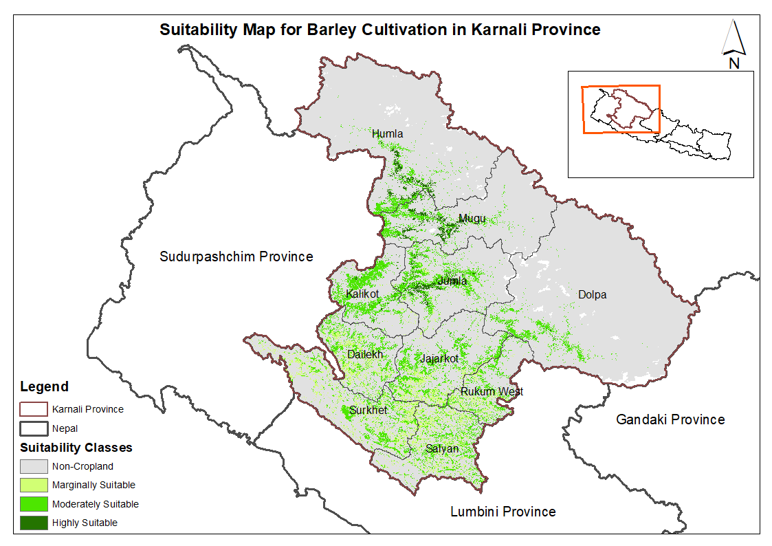
This dataset provides potential suitable area for cultivating barley in the Karnali Province, Nepal. It is one of the datasets produced through a land suitability analysis conducted for high value agricultural commodities in the province. The suitability analysis was based on the FAO's' land suitability framework, which evaluates the suitability of land for cultivation of specific crop using climatic, topographic and soil characteristics. The analysis was conducted by ICIMOD under the Himalayan Resilience Enabling Action Programme (HI-REAP) project to support data-driven decision making and promote sustainable and climate-resilient agriculture in Karnali Province.
-
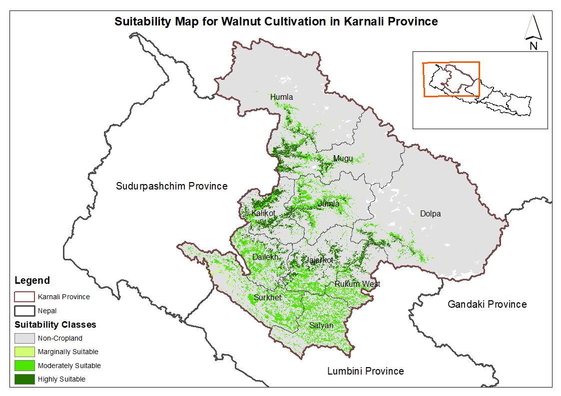
This dataset provides potential suitable area for cultivating walnut in the Karnali Province, Nepal. It is one of the datasets produced through a land suitability analysis conducted for high value agricultural commodities in the province. The suitability analysis was based on the FAO's' land suitability framework, which evaluates the suitability of land for cultivation of specific crop using climatic, topographic and soil characteristics. The analysis was conducted by ICIMOD under the Himalayan Resilience Enabling Action Programme (HI-REAP) project to support data-driven decision making and promote sustainable and climate-resilient agriculture in Karnali Province.
-
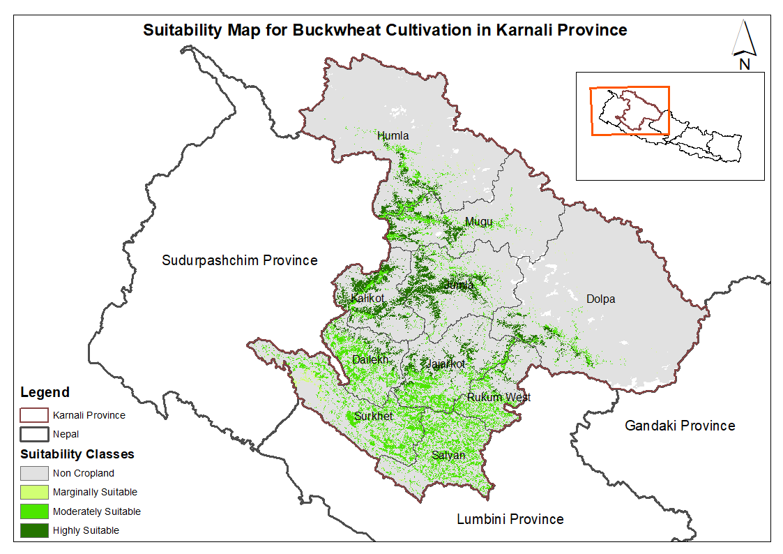
This dataset provides potential suitable area for cultivating buckwheat in the Karnali Province, Nepal. It is one of the datasets produced through a land suitability analysis conducted for high value agricultural commodities in the province. The suitability analysis was based on the FAO's' land suitability framework, which evaluates the suitability of land for cultivation of specific crop using climatic, topographic and soil characteristics. The analysis was conducted by ICIMOD under the Himalayan Resilience Enabling Action Programme (HI-REAP) project to support data-driven decision making and promote sustainable and climate-resilient agriculture in Karnali Province.
-
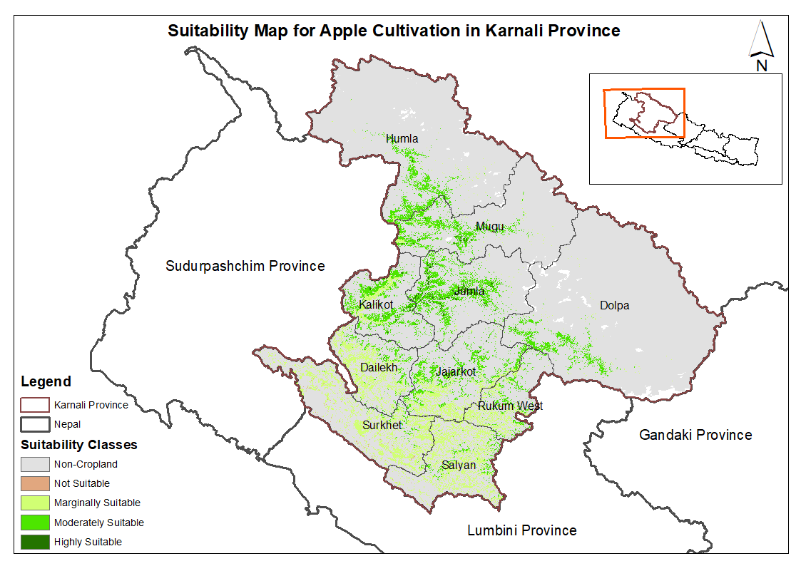
This dataset provides potential suitable area for cultivating apple in the Karnali Province, Nepal. It is one of the datasets produced through a land suitability analysis conducted for high value agricultural commodities in the province. The suitability analysis was based on the FAO's' land suitability framework, which evaluates the suitability of land for cultivation of specific crop using climatic, topographic and soil characteristics. The analysis was conducted by ICIMOD under the Himalayan Resilience Enabling Action Programme (HI-REAP) project to support data-driven decision making and promote sustainable and climate-resilient agriculture in Karnali Province.
-
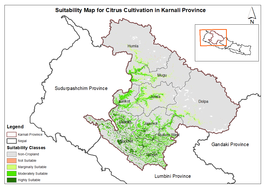
This dataset provides potential suitable area for cultivating citrus in the Karnali Province, Nepal. It is one of the datasets produced through a land suitability analysis conducted for high value agricultural commodities in the province. The suitability analysis was based on the FAO's' land suitability framework, which evaluates the suitability of land for cultivation of specific crop using climatic, topographic and soil characteristics. The analysis was conducted by ICIMOD under the Himalayan Resilience Enabling Action Programme (HI-REAP) project to support data-driven decision making and promote sustainable and climate-resilient agriculture in Karnali Province.
-
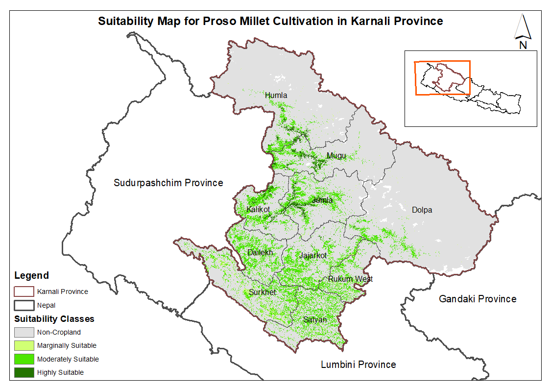
This dataset provides potential suitable area for cultivating proso millet in the Karnali Province, Nepal. It is one of the datasets produced through a land suitability analysis conducted for high value agricultural commodities in the province. The suitability analysis was based on the FAO's' land suitability framework, which evaluates the suitability of land for cultivation of specific crop using climatic, topographic and soil characteristics. The analysis was conducted by ICIMOD under the Himalayan Resilience Enabling Action Programme (HI-REAP) project to support data-driven decision making and promote sustainable and climate-resilient agriculture in Karnali Province.
-
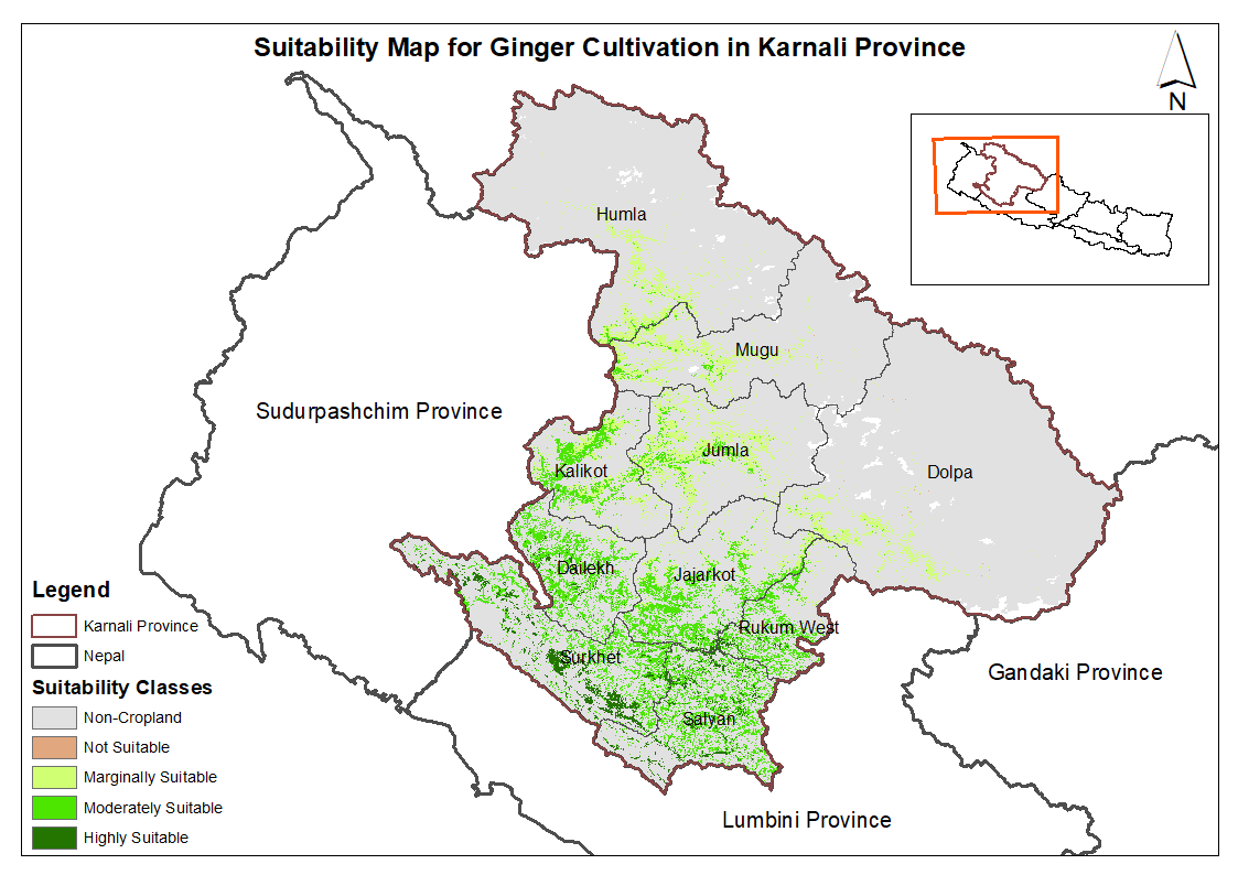
This dataset provides potential suitable area for cultivating ginger in the Karnali Province, Nepal. It is one of the datasets produced through a land suitability analysis conducted for high value agricultural commodities in the province. The suitability analysis was based on the FAO's' land suitability framework, which evaluates the suitability of land for cultivation of specific crop using climatic, topographic and soil characteristics. The analysis was conducted by ICIMOD under the Himalayan Resilience Enabling Action Programme (HI-REAP) project to support data-driven decision making and promote sustainable and climate-resilient agriculture in Karnali Province.
-
This is the first inventory of glacial lakes of Nepal Himalaya. The data is prepared using topographic maps, aerial photographs and satellite images.