 Metadata Catalogue
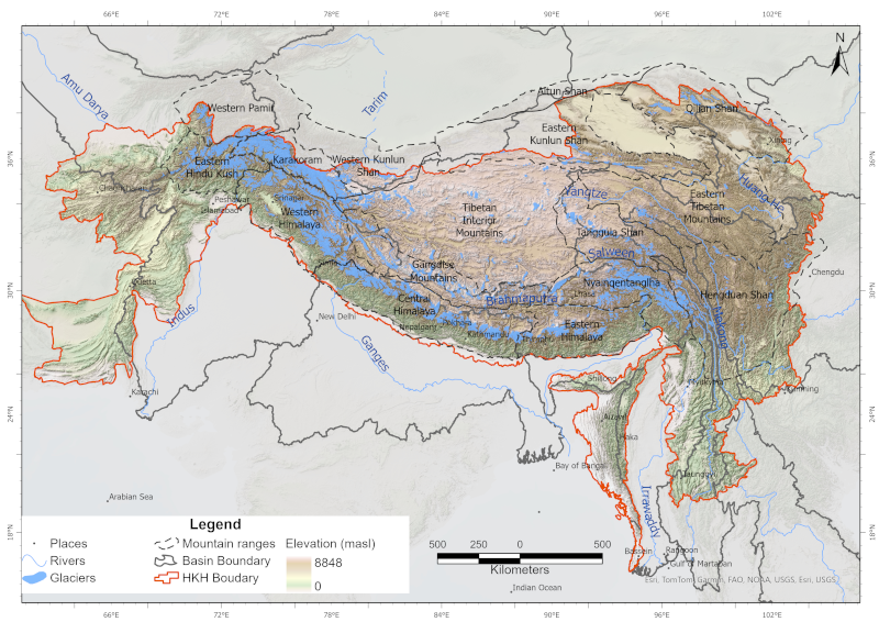
Irrawaddy
Type of resources
Available actions
Topics
Keywords
Contact for the resource
Provided by
Representation types
Update frequencies
status
Scale
-

Digital polygon data of Status of Glaciers in Hindu Kush Himalayan (HKH) Region during 2005 ± 3 (2002-2008) years. This dataset is created using Landsat ETM+ imageries of respective years. The glacier outlines was derived semi-automatically using object-based image classification (OBIC ) method separately for clean ice and debris cover and further editing and validation was done carefully by draping over the high resolution images from Google Earth. The attribute data were assigned to each glacier using 90m resolution SRTM DEM. Source: ICIMOD and CAREERI (data for the Chinese part of the HKH region is a product of a national project of the Ministry of Science and Technology of China (Grant no. 2006FY110200))
-

The comprehensive baseline information on the glacial lakes of the Hindu Kush Himalaya was generated semi-automatically using more than 200 Landsat 5 TM and Landsat 7 ETM+ images of 2005 ± 2 years with minimum cloud and snow coverage. The glacial lakes were mapped by using band ratio threshold condition method and some manual intervention. The attribute data were assigned using 90m resolution SRTM DEM.
-
The comprehensive baseline information on the glaciers of the HKH region was generated semi-automatically using more than 200 Landsat 7 ETM+ images of 2005 ± 3 years with minimum cloud and snow coverage. The glacier outlines were derived by using object-based image classification method separately for clean-ice and debris-covered glaciers with some manual intervention. The attribute data were assigned to each glacier using 90m resolution SRTM DEM. This data does not cover the China part.
-
Glaciers are an indispensable component of the Hindu Kush Himalayan (HKH) region, acting as a vast “water tower” that stores large volumes of freshwater and sustains Asia’s ten major river systems, supporting ecosystems, communities, and livelihoods across the continent. This study presents a decadal glacier change dataset for the HKH region developed using a semi-automatic mapping approach to ensure high accuracy and enable reliable comparison of glacier changes over time. The dataset was generated using consistent data sources and methods, with Landsat imagery from 1990, 2000, 2010, and 2020, maintaining a narrow temporal window (±1 year from the base year) and a uniform spatial resolution. Glacier outlines were mapped at a scale of 1:50,000 with a minimum area threshold of 0.02 km². Glacier area and associated topographic parameters were derived using the Albers Equal Area projection and the global void-filled SRTM DEM v4. This dataset represents a first-of-its-kind, region-wide glacier inventory created using a consistent methodology and data source, providing a comprehensive assessment of glacier distribution and decadal change across the entire HKH region.