 Metadata Catalogue
India
Type of resources
Available actions
Topics
Keywords
Contact for the resource
Provided by
Years
Representation types
Update frequencies
status
Scale
Resolution
-

Digital point data of pass locations of Kailash Sacred Landscape in Nepal.
-
Development Pressure Index (DPI): refers to the vulnerability due to the economic development activities in the basin. Parameters such as GDP growth, population growth, expansion of irrigated land, etc are accounted in this index.
-

Digital polygon data of wetland of Kailash Sacred Landscape.
-

Digital point data of Gloria site of Kailash Sacred Landscape.
-

Digital point data of touristic place of Kailash Sacred Landscape.
-
This layer gives information about the spatial location of important bird area lies in Kailash Sacred Landscape Area.
-
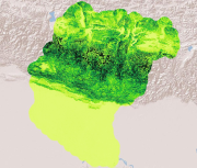
Digital grid dataset of Slope of Koshi Basin. This dataset is created using SRTM DEM 90 meter spatial resolution data.
-
This layer gives information about the 100 meters contour profile of Kailash Sacred Landscape.
-
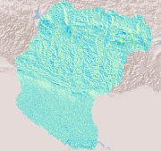
Digital grid dataset of Aspect of Koshi Basin. This dataset is created using SRTM DEM 90 meter spatial resolution data.
-
This layer gives information about the 1000 meters contour profile of Kailash Sacred Landscape.