 Metadata Catalogue
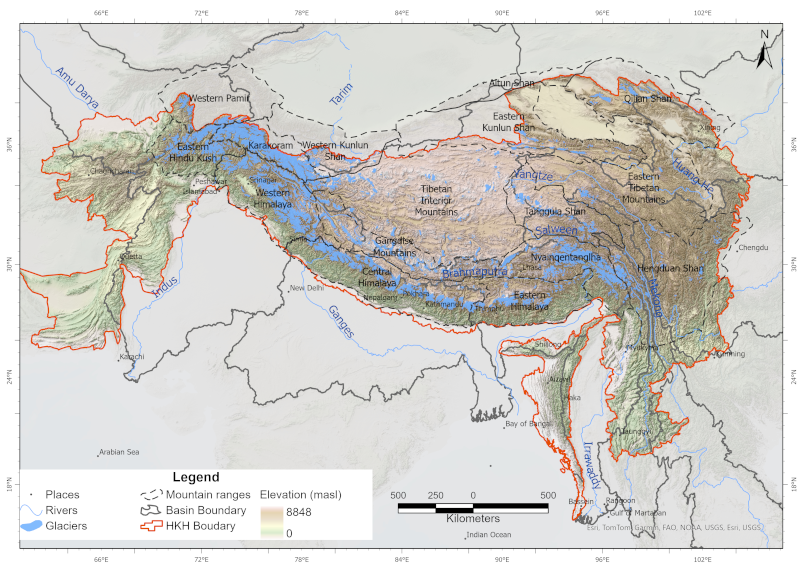
Hindu Kush Himalaya
Type of resources
Topics
Keywords
Contact for the resource
Provided by
Representation types
Update frequencies
status
Scale
Resolution
-
Mala GeoScience ProEx ground penetrating radar (GPR) with a 30 MHz Rough Terrain Antenna (RTA) to measure the ice thickness and thermal regime of Rikha Samba Glacier in 2015.
-
This is the first inventory of glacial lakes of Bhutan Himalaya. The data is prepared using topographic maps and satellite images of Bhutan.
-
Point thickness data of Rikha Samba glacier in Nepal collected with an impulse GPR transmitter (Ohio State University) with a set of half-wavelength 5 MHz dipole antennas in 2010. Data are published in Gilbert et al. 2020.
-
This is the first inventory of glaciers of Bhutan Himalaya. The data is prepared using topographic maps and satellite images of Bhutan.
-
This is the inventory of glacial lakes in the Nepal Himalaya. The inventory is prepared using Landsat satellite images of 2005/2006 and gives the distribution of glacial lakes at the sub-basin level. It also contains information about three potentially dangerous lakes based on their field investigation, along with the prioritization of critical lakes.
-
This is the first inventory of glacial lakes of Nepal Himalaya. The data is prepared using topographic maps, aerial photographs and satellite images.
-
Glaciers are an indispensable component of the Hindu Kush Himalayan (HKH) region, acting as a vast “water tower” that stores large volumes of freshwater and sustains Asia’s ten major river systems, supporting ecosystems, communities, and livelihoods across the continent. This study presents a decadal glacier change dataset for the HKH region developed using a semi-automatic mapping approach to ensure high accuracy and enable reliable comparison of glacier changes over time. The dataset was generated using consistent data sources and methods, with Landsat imagery from 1990, 2000, 2010, and 2020, maintaining a narrow temporal window (±1 year from the base year) and a uniform spatial resolution. Glacier outlines were mapped at a scale of 1:50,000 with a minimum area threshold of 0.02 km². Glacier area and associated topographic parameters were derived using the Albers Equal Area projection and the global void-filled SRTM DEM v4. This dataset represents a first-of-its-kind, region-wide glacier inventory created using a consistent methodology and data source, providing a comprehensive assessment of glacier distribution and decadal change across the entire HKH region.