 Metadata Catalogue
Himalaya
Type of resources
Topics
Keywords
Contact for the resource
Provided by
Representation types
Update frequencies
status
Scale
Resolution
-
This is the first inventory of glacial lakes of Bhutan Himalaya. The data is prepared using topographic maps and satellite images of Bhutan.
-
This is the first inventory of glaciers of Bhutan Himalaya. The data is prepared using topographic maps and satellite images of Bhutan.
-
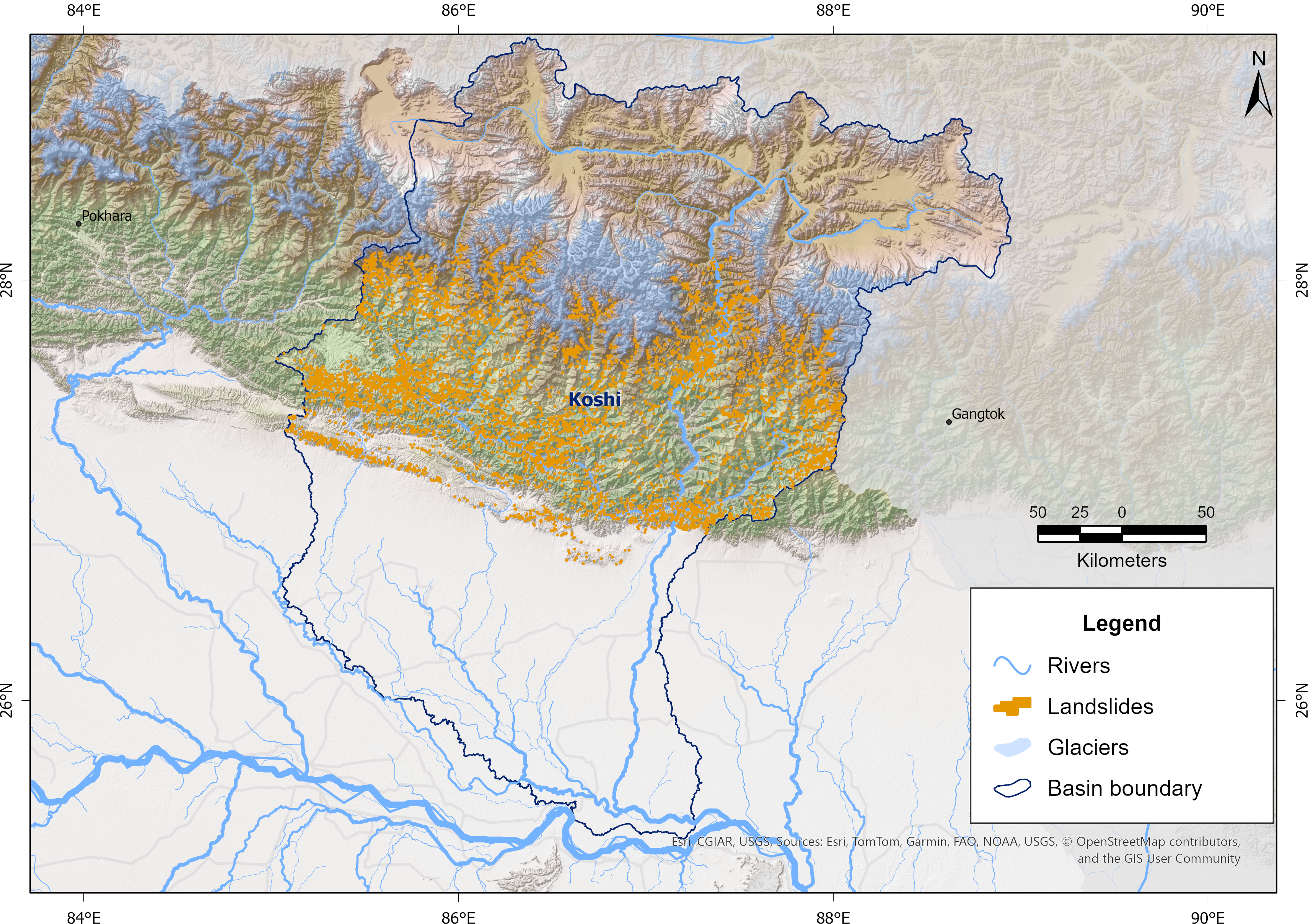
Landslides are a major natural hazard in the Himalayan region, causing significant damage to infrastructure, loss of life, and environmental impacts each year. The Koshi Basin is highly susceptible to landslides due to its steep terrain, intense monsoonal rainfall, active tectonics, and changing land use. To support hazard assessment and disaster risk reduction, a comprehensive landslide inventory of the Koshi Basin was developed using Sentinel-2 imagery and a U-Net-based semantic segmentation approach developed in collaboration with the University of Maryland, Baltimore County, and the NASA Goddard Space Flight Center (GSFC) for NASA’s High Mountain Asia Project. The model was trained using manually delineated multi-temporal landslide datasets from the 2015 Gorkha Earthquake-affected districts of Nepal, produced by NSET-Nepal and Durham University, UK, and accessed through NDRRMA. These automatically detected landslides were refined through manual editing and quality control, and the resulting dataset has been used for continued model improvement and training. The data were prepared as part of the Glacier to Ocean (G2O) Project of ICIMOD in collaboration with the Ocean Policy Research Institute of the Sasakawa Peace Foundation.
-
This is the first inventory of glaciers of Nepal Himalaya. The data is prepared using topographic maps, aerial photographs and satellite images.
-
This is the inventory of glacial lakes in the Nepal Himalaya. The inventory is prepared using Landsat satellite images of 2005/2006 and gives the distribution of glacial lakes at the sub-basin level. It also contains information about three potentially dangerous lakes based on their field investigation, along with the prioritization of critical lakes.
-
This is the first inventory of glacial lakes of Nepal Himalaya. The data is prepared using topographic maps, aerial photographs and satellite images.
-
Glaciers are an indispensable component of the Hindu Kush Himalayan (HKH) region, acting as a vast “water tower” that stores large volumes of freshwater and sustains Asia’s ten major river systems, supporting ecosystems, communities, and livelihoods across the continent. This study presents a decadal glacier change dataset for the HKH region developed using a semi-automatic mapping approach to ensure high accuracy and enable reliable comparison of glacier changes over time. The dataset was generated using consistent data sources and methods, with Landsat imagery from 1990, 2000, 2010, and 2020, maintaining a narrow temporal window (±1 year from the base year) and a uniform spatial resolution. Glacier outlines were mapped at a scale of 1:50,000 with a minimum area threshold of 0.02 km². Glacier area and associated topographic parameters were derived using the Albers Equal Area projection and the global void-filled SRTM DEM v4. This dataset represents a first-of-its-kind, region-wide glacier inventory created using a consistent methodology and data source, providing a comprehensive assessment of glacier distribution and decadal change across the entire HKH region.