 Metadata Catalogue
Health
Type of resources
Topics
Keywords
Contact for the resource
Provided by
Representation types
Update frequencies
status
Scale
Resolution
-
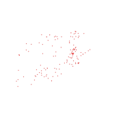
Digital point dataset of Location of Hospitals of Afghanistan. This dataset is created using 1:1,00,000 scale map of Afghanistan and derived from Afghanistan Information Management Systems (AIMS), Afghanistan.
-
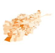
Digital polygon dataset of Population and Health Workers Ratio per District of Afghanistan. This dataset is acquired from ESRI Map & Data 2001 and Afghanistan Information Management Systems (AIMS), Afghanistan.
-
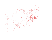
Digital point dataset of Location of Health posts of Afghanistan. This dataset is created using 1:1,000,000 scale map of Afghanistan and derived from Afghanistan Information Management Systems (AIMS), Afghanistan.
-

Digital point dataset of Veterinary Hospitals of Central Karakoram National Park (CKNP) area, Pakistan. This dataset is compiled through GPS based field survey conducted in year 2008.
-

Digital point dataset of Health facility of Central Karakoram National Park(CKNP) area, Pakistan. This dataset is compiled through GPS based field survey conducted in year 2008.
-
Resilient Mountain Solution (RMS) and RMS Poverty and Vulnerability Assessment (PVA) is a ward level household survey to have get a deeper understanding of Dadeldhura site. The survey was a part of the case study at covering multiple issues focusing on agricultural and animal husbandry practices, energy use, environmental and socioeconomic changes faced, their impact and coping to identify emerging issues, determinants of vulnerability and develop solution to improve their resilience for enhanced livelihoods. The survey covers 110 households across the 5 wards of Bhageswor rural municipality in Dadeldhura which was purposively selected. Household selection for the survey was done following random sampling method within the wards.