 Metadata Catalogue
Glacier
Type of resources
Available actions
Topics
Keywords
Contact for the resource
Provided by
Years
Representation types
Update frequencies
status
Scale
Resolution
-
Digital polygon dataset of Snow Cover Area of Pakistan. This dataset is Basic grid layer derived from ESRI Map & Data 2001.
-
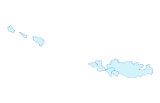
Digital polygon dataset of location of Gyoko lake of Nepal. This dataset is created using Landsat TM, IRS and IKONOS satellite imageries under ICIMOD partnership with Wetlands International, ARGEOPS and Asia ProEco.
-
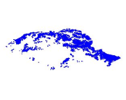
Digital polygon data of Glaciers of Hindu Kush Himalaya Region. This dataset is acquired from ESRI Map & Data Center in 2001.
-
Digital polygon data of Glaciers of Bhutan in 1980. This dataset is created using Landsat MSS imageries of 1980. The glacier outlines was derived semi-automatically using object-based image classification (OBIC ) method separately for clean ice and debris cover and further editing and validation was done carefully by draping over the high resolution images from Google Earth.
-

Digital polygon data of Glaciers of Bhutan in 2000. This dataset is created using Landsat TM and ETM+, imageries of 2000. The glacier outlines was derived semi-automatically using object-based image classification (OBIC ) method separately for clean ice and debris cover and further editing and validation was done carefully by draping over the high resolution images from Google Earth.
-

Digital polygon data of Glaciers of Bhutan in 2010. This dataset is created using Landsat TM and ETM+, imageries of 2010. The glacier outlines was derived semi-automatically using object-based image classification (OBIC ) method separately for clean ice and debris cover and further editing and validation was done carefully by draping over the high resolution images from Google Earth.
-

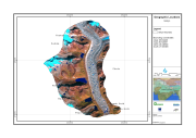
Digital polygon data of Glaciers of Central Karakoram National Park(CKNP) area, Pakistan. This dataset is created using topographic sheet maps at scale of 20000.
-

Digital polygon data of Glaciers of Bhutan in 1990. This dataset is created using Landsat MSS and TM imageries of 1990. The glacier outlines was derived semi-automatically using object-based image classification (OBIC ) method separately for clean ice and debris cover and further editing and validation was done carefully by draping over the high resolution images from Google Earth.
-
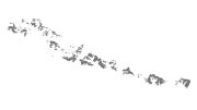
Digital polygon data of Glaciers of Nepal in 1980, 1990, 2000 and 2010. This dataset is created using Landsat MSS,TM and ETM+ imageries of four respective decades. The glacier outlines were derived semi-automatically using object-based image classification (OBIC ) method separately for clean ice and debris cover and further editing and validation was done carefully by draping over the high resolution images from Google Earth. Moreover, the glacier outlines for 2000, 1990 and 1980 were derived manually modifying the glacier outlines of 2010 by overlaying separately the images of respective decades.
-
The dataset shows areas identified as rock glaciers by two different persons (rock glacier mapping layer M1 and M2). It is obtained by intersecting M1 and M2 layer of rock glacier mapping.