 Metadata Catalogue
Glacial lake
Type of resources
Topics
Keywords
Contact for the resource
Provided by
Years
Representation types
Update frequencies
status
Scale
-
Digital polygon data of Glaciers, Glacial Lakes and Potential Glacial Lake Outburst Floods (GLOFs) locations of Nepal. This dataset is created using satellite images (Landsat, TM, ETM+ imageries) of of different years. The glacier and glacier lake outlines was derived semi-automatically using object-based image classification (OBIC). The dataset is created under Inventory of Glaciers, Glacial Lakes and the Identification of Potential Glacial Lake Outburst Floods (GLOFs) mapping in collaboration with United Nations Environment Programme /Regional Resource Centre for Asia and the Pacific (UNEP/RRC-AP).
-
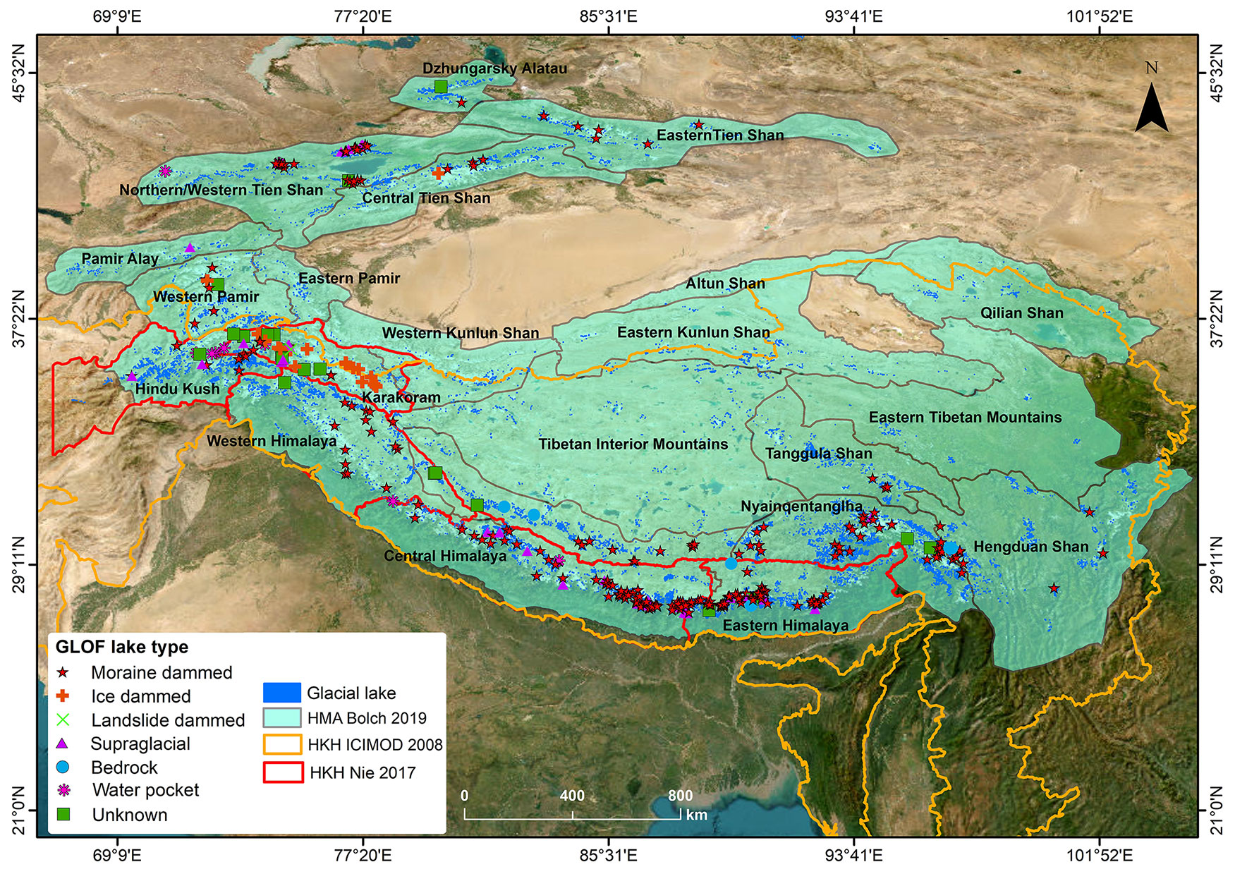
Glacier lake outburst floods (GLOFs) have been intensely investigated in High Mountain Asia (HMA) in recent years and are the most well-known hazard associated with the cryosphere. As glaciers recede and surrounding slopes become increasingly unstable, such events are expected to increase, although current evidence for an increase in events is ambiguous. Many studies have investigated individual events and while several regional inventories exist, they either do not cover all types of GLOF or are geographically constrained. Further, downstream impacts are rarely discussed. Previous inventories have relied on academic sources and have not been combined with existing inventories of glaciers and lakes. In this study, we present the first comprehensive inventory of GLOFs in HMA, including details on the time of their occurrence, processes of lake formation and drainage involved as well as downstream impacts. We document 766 individual GLOFs that occurred between 1533 and 2025. Of these, 23% were recurring events from just three ephemeral ice-dammed lakes. In combination, the documented events resulted in 8996 fatalities of which 906 fatalities were from 24 events, which is three times higher than a previous assessment for the region. The integration of previous inventories of glaciers and lakes within this database will inform future assessments of potential drivers of GLOFs, allowing more robust projections to be developed. The database and future, updated versions, are traceable, version controlled and can be directly incorporated into further analysis. This dataset has been updated in December 2025.
-

The glacial lakes of Afghanistan were mapped using Landsat image that were selected based in a one-year buffer surrounding a representative year. For instance, the Landsat images from 1989 to 1991 were used to represent 1990 depending on the quality of images (least snow cover and cloud cover). The glacial lakes were extracted semi-automatically through an object-based image classification (OBIC) method and were then subjected to manual editing for quality control. The attributes of the data were extracted from the SRTM DEM. This dataset was produced in collaboration between the National Water Affairs Regulation Authority (NWARA) of the Government of Afghanistan and ICIMOD as part of the SERVIR-HKH Initiative.
-

The glacial lakes of Afghanistan were mapped using Landsat image that were selected based in a one-year buffer surrounding a representative year. For instance, the Landsat images from 2014 to 2016 were used to represent 2015 depending on the quality of images (least snow cover and cloud cover). The glacial lakes were extracted semi-automatically through an object-based image classification (OBIC) method and were then subjected to manual editing for quality control. The attributes of the data were extracted from the SRTM DEM. This dataset was produced in collaboration between the National Water Affairs Regulation Authority (NWARA) of the Government of Afghanistan and ICIMOD as part of the SERVIR-HKH Initiative.
-
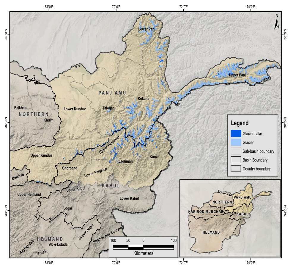
The glacial lakes of Afghanistan were mapped using Landsat image that were selected based in a one-year buffer surrounding a representative year. For instance, the Landsat images from 1999 to 2001 were used to represent 2000 depending on the quality of images (least snow cover and cloud cover). The glacial lakes were extracted semi-automatically through an object-based image classification (OBIC) method and were then subjected to manual editing for quality control. The attributes of the data were extracted from the SRTM DEM. This dataset was produced in collaboration between the National Water Affairs Regulation Authority (NWARA) of the Government of Afghanistan and ICIMOD as part of the SERVIR-HKH Initiative.
-
The glacial lakes of Afghanistan were mapped using Landsat image that were selected based in a one-year buffer surrounding a representative year. For instance, the Landsat images from 2009 to 2011 were used to represent 2010 depending on the quality of images (least snow cover and cloud cover). The glacial lakes were extracted semi-automatically through an object-based image classification (OBIC) method and were then subjected to manual editing for quality control. The attributes of the data were extracted from the SRTM DEM. This dataset was produced in collaboration between the National Water Affairs Regulation Authority (NWARA) of the Government of Afghanistan and ICIMOD as part of the SERVIR-HKH Initiative.
-

The comprehensive baseline information on the glacial lakes of the Hindu Kush Himalaya was generated semi-automatically using more than 200 Landsat 5 TM and Landsat 7 ETM+ images of 2005 ± 2 years with minimum cloud and snow coverage. The glacial lakes were mapped by using band ratio threshold condition method and some manual intervention. The attribute data were assigned using 90m resolution SRTM DEM.