 Metadata Catalogue
Glacial Lake
Type of resources
Available actions
Topics
Keywords
Contact for the resource
Provided by
Representation types
Update frequencies
status
Scale
-
Digital polygon dataset of location of Gyoko lake of Nepal. This dataset is created using Landsat TM, IRS and IKONOS satellite imageries under ICIMOD partnership with Wetlands International, ARGEOPS and Asia ProEco.
-

Digital polygon dataset of Glaciers in Sagarmatha National Park, SNP area. This dataset is extracted from inventory of glaciers and glacial lakes prepared by ICIMOD, 2002.
-

Digital polygon dataset of Glacial Lakes of Sagarmatha National Park, SNP Nepal. This dataset is extracted from inventory of glaciers and glacial lakes prepared by ICIMOD, 2002.
-
The Gorkha earthquake (M 7.8) on 25 April 2015 and later aftershocks struck South Asia, killing 9,000 and damaging a large region. Supported by a large campaign of responsive satellite data acquisitions over the earthquake disaster zone, our team undertook a satellite image survey of the earthquakes’ induced geohazards in Nepal and China and an assessment of the geomorphic, tectonic, and geologic controls on quake-induced landslides. Timely analysis and communication aided response and recovery and informed decision makers. We mapped 4312 co-seismic and post-seismic landslides and surveyed 491 glacier lakes for earthquake damage, but found only 9 landslide-impacted lakes and no visible satellite evidence of outbursts. Landslide densities are correlated with slope, peak ground acceleration, surface downdrop, and specific metamorphic lithologies and large plutonic intrusions.
-

The potentially dangerous glacial lakes were identified on the basis of the glacial lake inventory dataset using Landsat imagery from 2015. The following criteria were used for classifying the lakes: i) lake characteristics, ii) dam characteristics, iii) source/associate glacier characteristics, and iv) physical conditions of surroundings. Various parameters required for classifying such lakes were generated by using 5 m ALOS DEM for Nepal and 12.5 m ALOS DEM for China and India. Data include detailed analyses of land features and conditions using high-resolution images with 3D visualization on Google Earth. The dataset provides the size, type, and altitudinal distribution of such lakes, including the hazard rank of each lake. This dataset was prepared to support the Green Climate Fund project proposal formulated by UNDP Nepal.
-
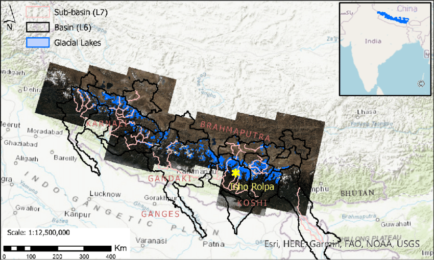
The data on glacial lakes in 2015 were derived through a semi-automatic method using Landsat imagery from 2015 to 2016. The Normalized Difference Water Index threshold value was used for classification. Further, the lake boundary was revised or manually updated by incorporating those lakes that were missed because of atmospheric and physical processes such as being frozen, covered under snow, or obstructed by shadows and clouds. The mapped glacial lakes were validated and modified where necessary by overlaying the Landsat imagery over previous inventory datasets. They were also cross-checked with high-resolution Google Earth imagery. The attributes of glacial lakes were derived from SRTM DEM, and the data were projected in the WGS UTM projection system. This dataset was prepared to support the Green Climate Fund project proposal formulated by UNDP Nepal.