 Metadata Catalogue
China
Type of resources
Available actions
Topics
Keywords
Contact for the resource
Provided by
Years
Representation types
Update frequencies
status
Scale
Resolution
-
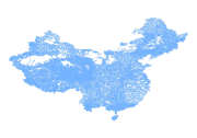
Digital line dataset of River system of China. This dataset is basic vector layer acquired from USGS.
-
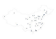
Digital point dataset of Location of Major Cities of China. This dataset is basic vector layer acquired from USGS.
-
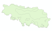
Digital polygon dataset of Eecoregions of Qomolangma Natural Preserve (QNP), Tibet, China.
-
This checklist contains a total of 8 mammal species documented from the China part of Kailash Sacred Landscape. This information has been collated from feasibility assessment report of the Kailash Sacred Landscape Conservation and Development Initiative and from IUCN websites.
-
Digital table data of Livestock population of Koshi Basin. The dataset is compiled using data sources from Statistical information on Nepalese agriculture, MoAD(2012); Economic Survey (2011/2012), Government of Bihar, India. Koshi basin consist more than 23 million big and medium sized livestock (cow, buffalo, sheep, goat and pig).
-

Digital point peak dataset of Kailash Sacred Landscape.
-

Digital point data of touristic place of Kailash Sacred Landscape.
-
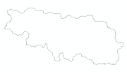
Digital polygon dataset of Administrative boundary of Qomolangma Natural Preserve (QNP), Tibet, China.
-
Digital polygon dataset of Hydrography of Qomolangma Natural Preserve (QNP), Tibet, China.
-
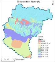
Digital polygon dataset of soil erosivity on Koshi Basin. The dataset is created using Soil maps of Nepal, India and FAO and represents the average long term soil response to the erosive power associated with rainfall and runoff. It shows a measure of the susceptibility of soil particles to detachment and transport by rainfall and runoff.