 Metadata Catalogue
Boundaries
Type of resources
Available actions
Topics
Keywords
Contact for the resource
Provided by
Years
Formats
Representation types
Update frequencies
status
Scale
Resolution
-

Digital line dataset of outline boundary of Hindu Kush Himalayan (HKH) Region. This dataset is Basic Vector layer derived from ESRI Map & Data 2001 and is in 1:1 million scale.
-
This layer gives information about the village boundary of Nepal that lies in Kailash Sacred Landscape.
-

Digital polygon data of boundary of Kailash Sacred Landscape.
-
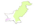
Digital polygon dataset of Major River Basins of Pakistan. This dataset is Basic Vector layer derived from ESRI Map & Data 2001.
-
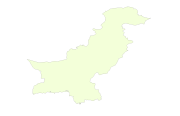
Digital polygon dataset of Country Boundary of Pakistan. This dataset is basic Vector layer acquired from ESRI Data and Maps, 2001.
-
Digital polygon data of ecological/vegetation zones of Nepal. This dataset is acquired from ESRI Map & Data Center in 2001.
-

This dataset shows the boundary of Kangchenjunga Landscape.
-
In the watershed level, existing lease hold forest boundary delineated to know the exact area under the lease hold forest. GeoEye-2009 image used for this pupose in the Kayerkhola watershed
-
Digital line dataset of Watershed Boundary of Phobjikha Valley, Bhutan. This dataset is created using topographic sheet maps at scale of 50000 and prepared by ICIMOD.
-
Digital polygon data of Village Development Committee, VDC Boundary of Kayar Khola Watershed, Chitwan, Nepal. This dataset is created using Topographic sheet data at scale of 25,000/50,000, of 1995 acquired from National Geographic Information Infrastructure Project (NGIIP), Dept. of Survey, Kathmandu, Nepal. The data was prepared for the Reducing Emission from Deforestation and Forest Degradation (REDD) Pilot Project. This is a joint project of ICIMOD with Asian Network for Sustainable Agriculture and Bio-resources (ANSAB) and Federation of Community for Forest Users of Nepal (FECOFUN) funded by NORAD.