 Metadata Catalogue
Bangladesh
Type of resources
Topics
Keywords
Contact for the resource
Provided by
Representation types
Update frequencies
status
Scale
Resolution
-
The dwelling vector digital data (polygon) layer of Chittagong Hill Tracts prepared based on Bangladesh Map.
-
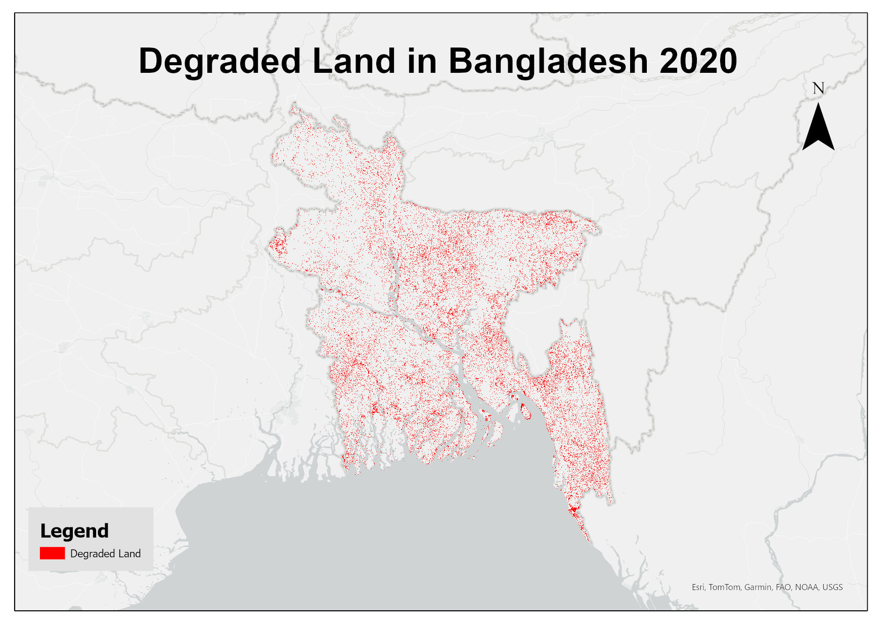
This dataset assesses land degradation in Bangladesh in 2020 based on SDG Indicator 15.3.1 by analyzing changes in land cover, land productivity, and soil organic carbon stocks. The 1OAO principle is applied in the computation method where changes in the sub-indicators are classified as improving, declining and stable. A land unit is considered degraded if any sub-indicator shows a negative or remains stable when previously degraded.
-
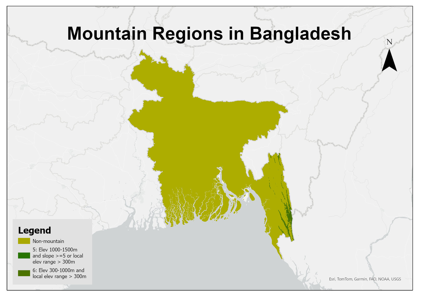
Digital raster dataset of mountain regions in Bangladesh. This dataset is prepared based on SRTM 30m resolution DEM showing different classes of mountains in the country defined by the Kapos et al. (2000): Class 1: elevation > 4500m; Class 2: elevation 3500–4500m; Class 3: elevation 2500-3500m; Class 4: elevation 1500–2500m and slope >= 2deg; Class 5: elevation 1000–1500m and slope >= 5deg or local elevation range (7km radius) > 300m; Class 6: elevation 300–1000m and local elevation range (7km radius) > 300m;
-
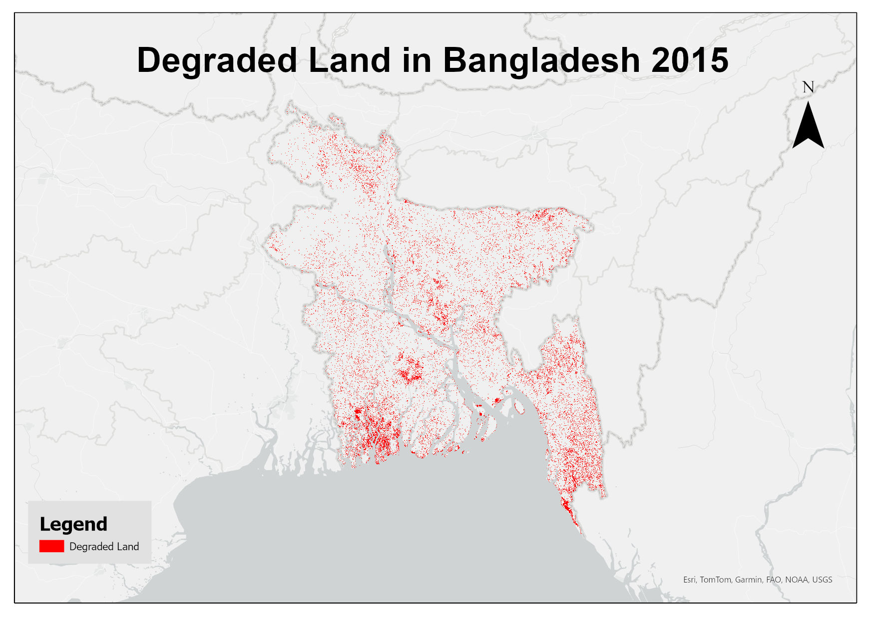
This dataset assesses land degradation in Bangladesh in 2015 based on SDG Indicator 15.3.1 by analyzing changes in land cover, land productivity, and soil organic carbon stocks. The 1OAO principle is applied in the computation method where changes in the sub-indicators are classified as improving, declining and stable. A land unit is considered degraded if any sub-indicator shows a negative or remains stable when previously degraded.
-

Land cover data of Greater Chittagong, Bangladesh for 1989. This dataset is created using the LandSat 30 meter spatial resolution satellite image of 1989.
-

Land cover data of Greater Chittagong, Bangladesh for 2010. This dataset is created using the LandSat 30 meter spatial resolution satellite image of 2000.
-

Bangladesh is one of the most flood affected country in the world. The frequency, intensity and duration of floods has been increased during last few decades. Due to increased population settlements in floodplains and irregular development damage of infrastructure, crop and property has increased creating severe impact on lives and livelihood. Understanding the severity and identification of extent and types of flood damage is highly important to plan effective response. The aim of this study was to develop appropriate methodology to determine extent of flood and damaged areas in near real time basis to support operational response. We have used Sentinel-1 synthetic aperture radar (SAR) images to generate flood extend data for the year 2017.
-

Land cover data of Greater Chittagong, Bangladesh for 2010. This dataset is created using the LandSat 30 meter spatial resolution satellite image of 2010.
-

The past few decades have seen high levels of deforestation and forest degradation in the Hindu Kush Himalayan (HKH) region. In this context, under SERVIR Himalaya programme, ICIMOD has developed forest cover monitoring system to identify forest change hotspot areas which need critical forest management attention in four pilot areas. This forest loss data of Bandarban, Bangladesh between 2010 and 2013 has been developed using LandSat 8 data in a semi-automated manner as part of the forest cover monitoring system.
-

Bangladesh is one of the most flood affected country in the world. The frequency, intensity and duration of floods has been increased during last few decades. Due to increased population settlements in floodplains and irregular development damage of infrastructure, crop and property has increased creating severe impact on lives and livelihood. Understanding the severity and identification of extent and types of flood damage is highly important to plan effective response. The aim of this study was to develop appropriate methodology to determine extent of flood and damaged areas in near real time basis to support operational response. We have used Sentinel-1 synthetic aperture radar (SAR) images to generate flood extend data for the year 2017.