 Metadata Catalogue
Afghanistan
Type of resources
Available actions
Topics
Keywords
Contact for the resource
Provided by
Years
Representation types
Update frequencies
status
Scale
Resolution
-
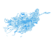
Digital polygon dataset of Drainage System of Afghanistan. This dataset is acquired from ESRI Data and Maps 2001.
-
Digital polygon dataset of School density per District of Afghanistan. This dataset is basic Vector layer derived from Afghanistan Information Management Systems (AIMS), Afghanistan.
-
Digital grid dataset of Monthly Mean Precipitation of June of Afghanistan. This dataset is acquired from USGS.
-
Digital grid dataset of Monthly Mean Precipitation of July of Afghanistan. This dataset is acquired from USGS.
-
Digital point dataset of Location of Hospitals of Afghanistan. This dataset is created using 1:1,00,000 scale map of Afghanistan and derived from Afghanistan Information Management Systems (AIMS), Afghanistan.
-
Digital polygon dataset of Major Habitat Areas of Afghanistan. This dataset is basic Vector layer acquired from ESRI Data and Maps 2001.
-
The rivers layer shows the shows the location, Length and direction of all rivers across the country.
-
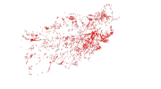
Digital line dataset of Geological fault lines of Afghanistan. This dataset is acquired from USGS.
-

Digital point dataset of Schools without Drinking Water access of Afghanistan. This dataset is basic vector layer derived from Afghanistan Information Management Systems (AIMS), Afghanistan.
-
The layer shows the roads in class 1 class 2 and class 3 all over the country