 Metadata Catalogue
Type of resources
Available actions
Topics
Keywords
Contact for the resource
Provided by
Years
Formats
Representation types
Update frequencies
status
Scale
Resolution
-
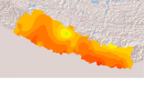
Average data for Whole Indus from year 1981 to 1990 for the month of March in ASCII format. It is an Aphrodite data with 0.25 resolution in x and y direction. The APHRODITE project develops state-of-the-art daily precipitation datasets with high-resolution grids. The datasets are created primarily with data obtained from a rain-gauge-observation network.
-
It provides a list of faunal species mainly Butterfly, Birds, Herptefauna and Mammals that were recorded in Kaminidaha plot within Parsa National Park, Nepal
-
This sensor measures precipitation volumes with the tipping technique, where each signal is a fixed volume of water. It is located next to a large Pluviometer on the left moraine (looking up-valley) or Langshisha Glacier in the Langtang Valley. It is no longer operational.
-
This Hydrological station shows the measurement of Water level and Rainfall at Gunitsawa, Bhutan.
-

Digital point dataset of fuel stations of Central Karakoram National Park (CKNP) area, Pakistan. This dataset is compiled through GPS based field survey conducted in year 2008.
-

The past few decades have seen high levels of deforestation and forest degradation in the Hindu Kush Himalayan (HKH) region. In this context, under SERVIR Himalaya programme, ICIMOD has developed forest cover monitoring system to identify forest change hotspot areas which need critical forest management attention in four pilot areas. This forest loss data of Sarlahi, Nepal between 2010 and 2013 has been developed using LandSat 8 data in a semi-automated manner as part of the forest cover monitoring system.
-
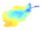
Digital grid dataset of Monthly Mean Temperature of July of Afghanistan. This dataset is acquired from USGS.
-
The dataset showing agricultural statistics of cash crops in Nepal. It consists of crop area, production and yield of oil seed, potato, tobacco and sugar cane for fiscal years from 2000/01 to 2013/14. The dataset is received from Ministry of Agricultural Development(MoAD), Nepal.
-
Daily mean sunshine duration of February 2001 of Nepal. This dataset is created using actual daily sunshine averages using Win-surfer and GIS-arc/info software packages. The mean values were derived from daily sunshine readings.
-
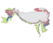
Digital polygon dataset of Honey Bee Dominant Zones of Hindu Kush Himalayan (HKH) Region created by ICIMOD.