Metadata Catalogue
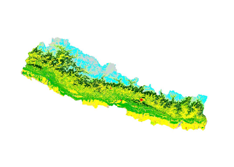
Land cover of Nepal 2010
Land cover and its change analysis across the Hindu Kush Himalayan (HKH) region is realized as an urgent need to support diverse issues of environmental conservation. This study presents the first and most complete national land cover database of Nepal prepared using public domain Landsat TM data of 2010 and replicable methodology. The study estimated that 41.9% of Nepal is covered by forests and 27.32% by agriculture. Comparative analysis with Landsat TM based global land cover product showed difference of the order of 30-60% among different land cover classes stressing the need for significant improvements for national level adoption. The online web based land cover validation tool is developed for continual improvement of land cover product. The potential use of the data set for national and regional level sustainable land use planning strategies and meeting several global commitments also highlighted.
Simple
- Date ( Publication )
- 2013-04-12
Author
ICIMOD
-
Mr. Kabir Uddin
(
GIS and Remote Sensing Analyst
)
977-1-5003299
Khumaltar
,
Kathmandu
,
Khumaltar, Lalitpur
,
3226
,
Nepal
977-1-5275222
977-1-5003299
- Other citation details
- ICIMOD. (2013). Land cover of Nepal 2010 [Data set]. ICIMOD. https://doi.org/10.26066/RDS.9224
- Purpose
- Development of baseline information for environmental management.
- Credit
- This dataset has been developed by SERVIR Himalaya. SERVIR is a joint USAID-NASA project. For more information on SERVIR, visit http://www.servirglobal.net.
- Status
- Completed
- Maintenance and update frequency
- Not planned
- ( Theme )
-
- Land cover
- Land use
- servircat
- icimod-servir
- Keywords ( Place )
-
- Nepal
Resource constraints
- Use limitation
- geossDataCore
- Use limitation
- Creative Commons Attribution 4.0 International (CC BY 4.0)
- Access constraints
- License
- Distance
- 30 m
- Metadata language
- eng
- Character set
- UTF8
- Topic category
-
- Geoscientific information
N
S
E
W
))
- Reference system identifier
- WGS 1984
Distributor
ICIMOD
-
Mr. Govinda Joshi
(
Senior Cartographer/GIS Analyst
)
977-1-5003299
Khumaltar
,
Kathmandu
,
Khumaltar, Lalitpur
,
3226
,
Nepal
977-1-5275222
977-1-5003299
- OnLine resource
- Reference ( WWW:LINK-1.0-http--related )
- OnLine resource
-
Data Download
(
WWW:LINK-1.0-http--related
)
Data Download
- Hierarchy level
- Dataset
- File identifier
- d14414d0-a356-4843-8bbb-ebcbb6630017 XML
- Metadata language
- eng
- Character set
- UTF8
- Hierarchy level
- Dataset
- Date stamp
- 2026-01-30T16:28:18
- Metadata standard name
- ISO 19115:2003/19139
Author
ICIMOD, SERVIR Himalaya
-
Mr. Sameer Bajracharya
(
Research Associate GIS
)
977-1-5003299
Khumaltar
,
Kathmandu
,
Khumaltar, Lalitpur
,
3226
,
Nepal
977-1-5275222
977-1-5003299