 Metadata Catalogue
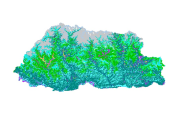
Land Cover of Bhutan 2010
Land cover data of Bhutan for 2010. This dataset is created using the LandSat 30 meter spatial resolution satellite image of 2010.
Simple
- Date ( Publication )
- 2011-12-27T11:31:00
- Edition
- First
- Identifier
- bt
- Presentation form
- Digital image
- Other citation details
- ICIMOD. (2011). Land Cover of Bhutan 2010 [Data set]. ICIMOD. https://doi.org/10.26066/rds.8880
- Purpose
- Locational base data for general purpose and Assessment and Monitoring of land Cover dynamics in Bhutan.
- Credit
- This dataset has been developed by SERVIR Himalaya. SERVIR is a joint USAID-NASA project. For more information on SERVIR, visit http://www.servirglobal.net.
- Status
- Completed
Author
ICIMOD
-
Mr. Him Lal Shrestha
(
Remote Sensing Analyst
)
977 1 5003299
ICIMOD
,
Kathmandu
,
Khumaltar lalitpur
,
GPO Box 3226
,
Nepal
977 1 5275222
977 1 5003299
Author
ICIMOD
-
Hammad Gilani
(
Remote Sensing Analyst
)
977 1 5003299
ICIMOD
,
Kathmandu
,
Khumaltar lalitpur
,
GPO Box 3226
,
Nepal
977-1-5275222
977 1 5003299
- Maintenance and update frequency
- As needed
- Keywords ( Theme )
-
- Land Cover Classification
- Land use
- Land cover
- servircat
- icimod-servir
- Keywords ( Place )
-
- Bhutan
Resource constraints
- Use limitation
- geossDataCore
- Use limitation
- Creative Commons Attribution 4.0 International (CC BY 4.0)
- Use limitation
- Users are permitted to copy, use, adapt, and redistribute SERVIR data without limitations. SERVIR encourages users to keep any adapted or redistributed versions of this data freely available for public use.
- Access constraints
- License
- Use constraints
- License
- Denominator
- 50000
- Metadata language
- eng
- Character set
- UTF8
- Topic category
-
- Geoscientific information
N
S
E
W
))
- Reference system identifier
- WGS 1984
- OnLine resource
-
Data Download
(
WWW:LINK-1.0-http--related
)
Data Download
- Hierarchy level
- Dataset
- File identifier
- be85f96a-3b55-4241-ae2c-4aa1326c0f44 XML
- Metadata language
- eng
- Character set
- UTF8
- Date stamp
- 2026-01-20T14:02:33
- Metadata standard name
- ISO 19115:2003/19139
- Metadata standard version
- 1.0
Author
ICIMOD, SERVIR Himalaya
-
Mr. Himlal Shrestha
(
Remote Sensing Analyst
)
977 1 5003299
ICIMOD
,
Kathmandu
,
Khumaltar lalitpur
,
GPO Box 3226
,
Nepal
977 1 5275222
977 1 5003299
Overviews
thumbnail

large_thumbnail
Spatial extent
N
S
E
W
Provided by

Associated resources
Not available