 Metadata Catalogue
Decadal glacier changes from 1990 to 2020 in the Hindu Kush Himalaya
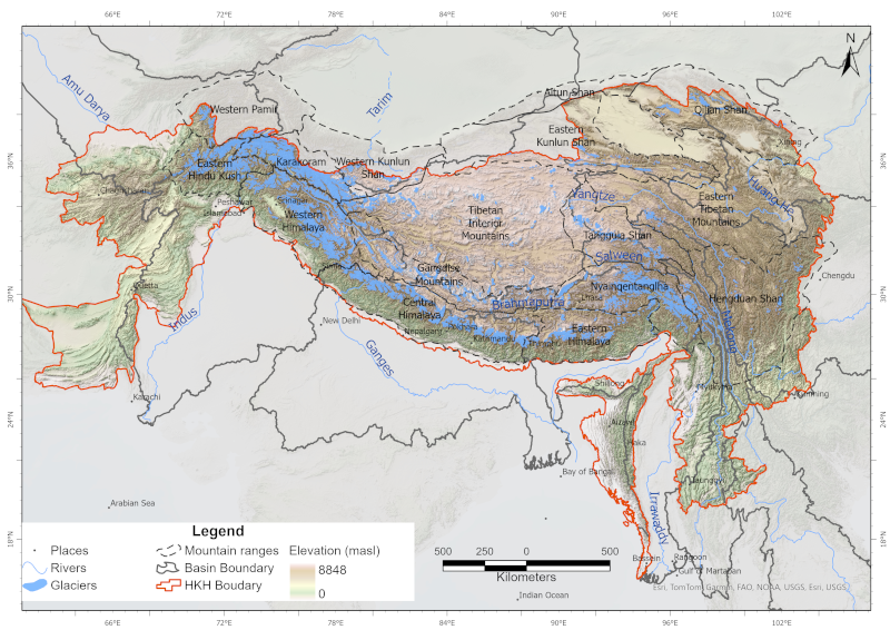
Glaciers are an indispensable component of the Hindu Kush Himalayan (HKH) region, acting as a vast “water tower” that stores large volumes of freshwater and sustains Asia’s ten major river systems, supporting ecosystems, communities, and livelihoods across the continent. This study presents a decadal glacier change dataset for the HKH region developed using a semi-automatic mapping approach to ensure high accuracy and enable reliable comparison of glacier changes over time. The dataset was generated using consistent data sources and methods, with Landsat imagery from 1990, 2000, 2010, and 2020, maintaining a narrow temporal window (±1 year from the base year) and a uniform spatial resolution. Glacier outlines were mapped at a scale of 1:50,000 with a minimum area threshold of 0.02 km². Glacier area and associated topographic parameters were derived using the Albers Equal Area projection and the global void-filled SRTM DEM v4. This dataset represents a first-of-its-kind, region-wide glacier inventory created using a consistent methodology and data source, providing a comprehensive assessment of glacier distribution and decadal change across the entire HKH region.
Simple
- Date ( Publication )
- 2026-03-19
- Other citation details
- ICIMOD. (2026). Decadal glacier changes from 1990 to 2020 in the Hindu Kush Himalaya [Data set]. ICIMOD. https://doi.org/10.26066/rds.1973447
- Purpose
- The dataset presents the status and decadal changes of glaciers from 1990 to 2020 covering entire HKH region. It serves as a valuable resource for researchers, scientists, and policymakers in managing glacier meltwater resources, studying climate change impacts, assessing glacial hazards, and planning risk reduction and mitigation strategies.
- Status
- Completed
- Maintenance and update frequency
- As needed
- ( Theme )
-
- Glacier
- Cryosphere
- Decadal Change
- Glacier Change
- Debris-covered
- Clean Ice
- Keywords ( Place )
-
- Hindu Kush Himalaya
- Mountain ranges
- Himalaya
- Karakoram
- Gangdise
- Ganges
- Indus
- Amu Darya
- Brahmaputra
- Irrawaddy
- Salween
- Mekong
- Yangtze
- Yellow River
- Tarim
- Qinghai Tibetan
- Nyainqêntanglha
- Hengduan Shan
- Tanggula Shan
- Tibetan
- Qilian Shan
- Kunlun Shan
- Pamir
- Altun Shan
- Use limitation
- Creative Commons Attribution 4.0 International (CC BY 4.0)
- Access constraints
- License
- Use constraints
- License
- Metadata language
- eng
- Character set
- UTF8
- Topic category
-
- Geoscientific information
N
S
E
W
))
- Reference system identifier
- WGS 1984
- OnLine resource
-
Changing Dynamics of Glaciers in the Hindu Kush Himalayan Region from 1990 to 2020
(
WWW:LINK-1.0-http--link
)
ICIMOD Research Report
- Hierarchy level
- Dataset
- File identifier
- b80287b9-2978-48c2-b386-bd5f1449d84f XML
- Metadata language
- eng
- Character set
- UTF8
- Hierarchy level
- Dataset
- Date stamp
- 2026-03-17T14:07:10
- Metadata standard name
- North American Profile of ISO 19115:2003
Overviews
hkh_glacier.png
Spatial extent

Provided by

Associated resources
Not available