Metadata Catalogue
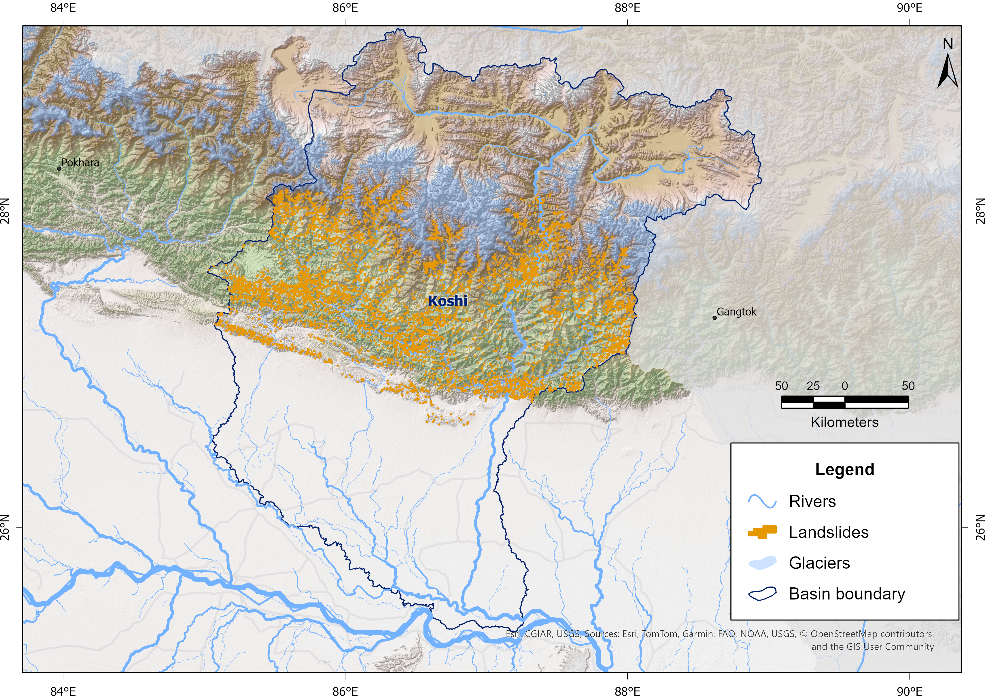
Landslide Inventory of Koshi Basin 2024
Landslides are a major natural hazard in the Himalayan region, causing significant damage to infrastructure, loss of life, and environmental impacts each year. The Koshi Basin is highly susceptible to landslides due to its steep terrain, intense monsoonal rainfall, active tectonics, and changing land use. To support hazard assessment and disaster risk reduction, a comprehensive landslide inventory of the Koshi Basin was developed using Sentinel-2 imagery and a U-Net-based semantic segmentation approach developed in collaboration with the University of Maryland, Baltimore County, and the NASA Goddard Space Flight Center (GSFC) for NASA’s High Mountain Asia Project. The model was trained using manually delineated multi-temporal landslide datasets from the 2015 Gorkha Earthquake-affected districts of Nepal, produced by NSET-Nepal and Durham University, UK, and accessed through NDRRMA. These automatically detected landslides were refined through manual editing and quality control, and the resulting dataset has been used for continued model improvement and training. The data were prepared as part of the Glacier to Ocean (G2O) Project of ICIMOD in collaboration with the Ocean Policy Research Institute of the Sasakawa Peace Foundation.
Simple
- Date ( Publication )
- 2026-03-19
- Other citation details
- ICIMOD. (2026). Landslide Inventory of Koshi Basin 2024 [Data set]. ICIMOD. https://doi.org/10.26066/rds.1973522
- Purpose
- The 2024 landslide dataset was developed using advanced remote sensing techniques based on Sentinel-2 satellite imagery and a U-Net-based semantic segmentation model, combined with manual editing and quality control procedures. The dataset serves as an important resource for researchers, scientists, and practitioners involved in landslide hazard assessment, disaster risk reduction, and environmental management within the Koshi Basin of the Himalayan region. It is designed to enhance understanding of landslide distribution and spatial patterns, support risk-informed planning and infrastructure development, and strengthen disaster preparedness and response efforts. Furthermore, the inventory contributes to ongoing model training, validation, and scientific research under collaborative initiatives, including NASA’s High Mountain Asia Project implemented jointly by UMBC, NASA GSFC, and ICIMOD, as well as the Glacier to Ocean (G2O) Project led by ICIMOD and its partners.
- Status
- Required
- Maintenance and update frequency
- Unknown
- ( Place )
-
- Koshi basin
- Himalaya
- Nepal
- Glacier to Ocean Project
- NASA HMA project
- Keywords ( Theme )
-
- Landslide
- Landslide hazard assessment
- Disaster
- Use limitation
- Creative Commons Attribution 4.0 International (CC BY 4.0)
- Access constraints
- License
- Use constraints
- License
- Metadata language
- eng
- Character set
- UTF8
- Topic category
-
- Geoscientific information
N
S
E
W
))
- Reference system identifier
- WGS 1984
- Hierarchy level
- Dataset
- File identifier
- af73da0a-885b-459d-95ba-2ea0662a7e7c XML
- Metadata language
- eng
- Character set
- UTF8
- Hierarchy level
- Dataset
- Date stamp
- 2026-05-15T15:51:35
- Metadata standard name
- North American Profile of ISO 19115:2003