 Metadata Catalogue
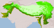
Mountain Regions of Hindu Kush Himalayan (HKH) Region
Digital raster dataset of Mountain regions of Hindu Kush Himalayan (HKH) Region. This dataset is prepared based on GTOPO 1km resolution DEM showing different classes of mountains in HKH region.
Simple
- Date ( Publication )
- 2011-07-27T09:46:00
- Edition
- First
- Identifier
- np
- Presentation form
- Digital image
- Other citation details
- ICIMOD. (2022). Mountain Regions of Hindu Kush Himalayan (HKH) Region [Data set]. ICIMOD. https://doi.org/10.26066/RDS.8743
- Purpose
- This is intended to show different classes of mountain of mountain regions in HKH region.
- Status
- Completed
Point of contact
ICIMOD
-
(
)
ICIMOD
,
Kathmandu
,
Khumaltar lalitpur
,
GPO Box 3226
,
Nepal
977-1-5275222
- Maintenance and update frequency
- As needed
- Keywords ( Theme )
-
- Mountain
- Topography
- Keywords ( Place )
-
- Hindu Kush Himalayan Region
- HKH Region
- Use limitation
- Creative Commons Attribution 4.0 International (CC BY 4.0)
- Access constraints
- License
- Use constraints
- License
- Spatial representation type
- Grid
- Distance
- 800 m
- Metadata language
- eng
- Character set
- UTF8
- Topic category
-
- Location
N
S
E
W
))
- Supplemental Information
- The definition of mountain classes are given in the paper by Kapos et al (2000): Kapos V, Rhind J, Edwards M, Ravilious C, Price MF. 2000. Developing a map of the world’s mountain forests. In: Price MF, Butt N, editors. Forestsin Sustainable Mountain Development. A State-of-Knowledge Report for 2000. Wallingford, UK: CAB International, pp 4–9. The mountain classes are Class 1: elevation > 4500 m ; Class 2: elevation 3500 – 4500 m ; Class 3: elevation 2500 – 3500 m ; Class 4: elevation 1500 – 2500 m and slope >= 20 ; Class 5: elevation 1000 – 1500 m and slope >= 50 or local elevation range (7 km radius) > 300 m ; Class 6: elevation 300 – 1000 m and local elevation range (7 km radius) > 300 m
- Reference system identifier
- WGS 1984
- Hierarchy level
- Dataset
- File identifier
- a80f7f29-d874-49d5-b508-24850a69edf9 XML
- Metadata language
- eng
- Character set
- UTF8
- Date stamp
- 2026-01-30T16:26:51
- Metadata standard name
- ISO 19115:2003/19139
- Metadata standard version
- 1.0
Author
ICIMOD
-
Sameer Bajracharya
(
Research Associate GIS Developer
)
ICIMOD
,
Kathmandu
,
Khumaltar lalitpur
,
GPO Box 3226
,
Nepal
977-1-5275222
Overviews
thumbnail

large_thumbnail
Spatial extent
N
S
E
W
Provided by

Associated resources
Not available