 Metadata Catalogue
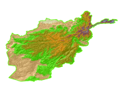
Elevation Zones of Afghanistan
Simple
- Date ( Publication )
- 2008-05-21T15:41:00
- Edition
- First
- Identifier
- af
- Purpose
- Topographic base data for general purpose
- Status
- Completed
977-1-5003299
- Maintenance and update frequency
- As needed
- Keywords ( Theme )
-
- DEM
- Topography
- Keywords ( Place )
-
- Afghanistan
- Access constraints
- Copyright
- Use constraints
- Other restrictions
- Other constraints
- The content of this website can be accessed, printed and downloaded in an unaltered form (altered including being stretched, compressed, coloured or altered in any way so as to distort content from its original proportions or format) with copyright acknowledged, on a temporary basis for personal study that is not for a direct or indirect commercial use and any non-commercial use. Any content printed or downloaded may not be sold, licensed, transferred, copied or reproduced in whole or in part in any manner or in or on any media to any person without the prior written consent of the ICIMOD
- Spatial representation type
- Grid
- Denominator
- 1000000
- Metadata language
- eng
- Character set
- UTF8
- Topic category
-
- Elevation
))
- Supplemental Information
-
Projection: GCS_Assumed_Geographic_1
Geodetic Model
Horizontal Datum Name: D_WGS_1984
Ellipsoid Name: WGS_1984
Semi-major Axis: 6378137.000000
Denominator of Flattening Ratio: 298.257224
Geographic coordinate system name: GCS_WGS_1984
Details
Geographic Coordinate System
Geographic Coordinate Units: Decimal degrees
Planar Coordinate Information
Coordinate Encoding Method: row and column
Coordinate Representation
Abscissa Resolution: 0.000833
Ordinate Resolution: 0.000833
- Reference system identifier
- WGS_1984
977-1-5003299
- Hierarchy level
- Dataset
- Statement
- The accuracy of the Digital Data prepared depends on the base source Data and Maps. No assessment or ground truthing has been carried out on this data. ICIMOD accepts no responsibility for any inaccuracy, errors, or omissions in this data.
- File identifier
- a425099f-bfa3-4fbf-a988-9415f9aa6975 XML
- Metadata language
- eng
- Character set
- UTF8
- Date stamp
- 2020-09-08T13:55:36
- Metadata standard name
- ISO 19115:2003/19139
- Metadata standard version
- 1.0
977-1-5003299
Overviews

Spatial extent
Provided by
