 Metadata Catalogue
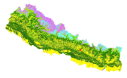
Land cover of Nepal 2000
Land cover and its change analysis across the Hindu Kush Himalayan (HKH) region is realized as an urgent need to support diverse issues of environmental conservation. This study presents the first and most complete national land cover database of Nepal prepared using public domain Landsat TM data of 2000 and replicable methodology. The study estimated that 41.64% of Nepal is covered by forests and 27.77% by agriculture. Physiographic regions wise forest fragmentation analysis revealed specific conservation requirements for productive hill and mid mountain regions. Comparative analysis with Landsat TM based global land cover product showed difference of the order of 30-60% among different land cover classes stressing the need for significant improvements for national level adoption. The online web based land cover validation tool is developed for continual improvement of land cover product. The potential use of the data set for national and regional level sustainable land use planning strategies and meeting several global commitments also highlighted.
Simple
- Date ( Publication )
- 2014-10-31
- Other citation details
- ICIMOD. (2014). Land cover of Nepal 2000 [Data set]. ICIMOD. https://doi.org/10.26066/rds.19590
- Purpose
- Development of baseline information for environmental management.
- Status
- Completed
- Maintenance and update frequency
- As needed
- Keywords ( Theme )
-
- Land cover
- Land use
- servircat
- icimod-servir
- Keywords ( Place )
-
- Nepal
- Use limitation
- The content of this website can be accessed, printed and downloaded in an unaltered form (altered including being stretched, compressed, coloured or altered in any way so as to distort content from its original proportions or format) with copyright acknowledged, on a temporary basis for personal study that is not for a direct or indirect commercial use and any non-commercial use. Any content printed or downloaded may not be sold, licensed, transferred, copied or reproduced in whole or in part in any manner or in or on any media to any person without the prior written consent of the ICIMOD.
- Use limitation
- Creative Commons Attribution 4.0 International (CC BY 4.0)
- Use limitation
- The SERVIR Project, NASA, USAID and ICIMOD make no express or implied warranty of this data as to the merchantability or fitness for a particular purpose. Neither the US Government nor its contractors shall be liable for special, consequential or incidental damages attributed to this data.
- Access constraints
- License
- Use constraints
- License
- Distance
- 30 m
- Metadata language
- eng
- Character set
- UTF8
- Topic category
-
- Geoscientific information
N
S
E
W
))
- Reference system identifier
- WGS 1984
- Hierarchy level
- Dataset
- Description
- The GeoEye-1 Satellite sensor features the most sophisticated technology ever used in a commercial remote sensing system. This newly developed sensor is optimized for large projects, as it can collect over 350,000 square kilometers of pan-sharpened multispectral satellite imagery every day.
- File identifier
- 8b3a6898-1645-44a3-9a21-0e55c5ddd0ab XML
- Metadata language
- eng
- Character set
- UTF8
- Hierarchy level
- Dataset
- Date stamp
- 2026-01-21T11:26:56
- Metadata standard name
- North American Profile of ISO 19115:2003
Overviews
thumbnail

large_thumbnail
Spatial extent

Provided by

Associated resources
Not available