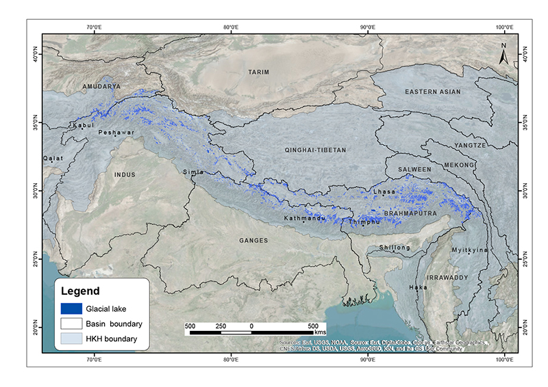
The comprehensive baseline information on the glacial lakes of the Hindu Kush Himalaya was generated semi-automatically using more than 200 Landsat 5 TM and Landsat 7 ETM+ images of 2005 ± 2 years with minimum cloud and snow coverage. The glacial lakes were mapped by using band ratio threshold condition method and some manual intervention. The attribute data were assigned using 90m resolution SRTM DEM.
| Schema | iso19139 |
| Purpose | This data provides the status and baseline information of glacial lakes to the researchers, scientists and policy makers in the field of glacier melt water resource management, impact of climate change study, GLOF hazard and risk assessment, and mitigation measures. |
| Descriptive Keyword | Glacial Lakes, Status, GLOF, Cryosphere (theme) HKH, Amu Darya, Indus, Ganges, Brahmaputra, Irrawaddy, Afghanistan, Bhutan, China, India, Nepal, Pakistan (place) |
| Metadata Record Info | |
|---|---|
| Language | eng |
| Charset | utf8 |
| Hierarchy Level | dataset |
| Date | 2020-09-08T14:38:06 |
| Standard Name | North American Profile of ISO 19115:2003 |
| Contact | |||
|---|---|---|---|
| Name | Mr. Sudan Bikash Maharjan | Sudan.Maharjan@icimod.org | |
| Organization Name | ICIMOD | Voice | |
| Position name | Remote Sensing Analyst - Cryosphere | Address | |
| Role | author | ||
| Identification Info | |
|---|---|
| Title | The Status of Glacial Lakes in the Hindu Kush Himalaya |
| Date | 2018-03-19 |
| Date Type | publication |
| Abstract | The comprehensive baseline information on the glacial lakes of the Hindu Kush Himalaya was generated semi-automatically using more than 200 Landsat 5 TM and Landsat 7 ETM+ images of 2005 ± 2 years with minimum cloud and snow coverage. The glacial lakes were mapped by using band ratio threshold condition method and some manual intervention. The attribute data were assigned using 90m resolution SRTM DEM. |
| Purpose | This data provides the status and baseline information of glacial lakes to the researchers, scientists and policy makers in the field of glacier melt water resource management, impact of climate change study, GLOF hazard and risk assessment, and mitigation measures. |
| Status | completed |
| Charset | utf8 |
| Topic Category | geoscientificInformation |
| Spatial Representation Type | vector |
| Equivalent Scale | 50000 |
| Cited Responsible Parties | |||
|---|---|---|---|
| Name | Mr. Sudan Bikash Maharjan | Sudan.Maharjan@icimod.org | |
| Organization Name | ICIMOD | Voice | 977-1-5075222 |
| Position name | Remote Sensing Analyst - Cryosphere | Address | Nepal |
| Role | author | ||
| Geographic Extent | |||
|---|---|---|---|
| Geographic Extent East | 98.424 | Geographic Extent West | 68.355 |
| Geographic Extent North | 38.327 | Geographic Extent South | 27.238 |
| Resource Maintenance Information | |
|---|---|
| Maintenance and update frequency | notPlanned |
| User Defined Maintenance Frequency | |
| Date of Next Update | |
| Legal Constraints | |
|---|---|
| Use Limitation | Free to use with attribution to the source. Suggested citation: ICIMOD. (2018). The Status of Glacial Lakes in the Hindu Kush Himalaya [Data set]. ICIMOD. https://doi.org/10.26066/RDS.35856 |
| Use Limitation | Free to use with copyright to ICIMOD. Citation: Maharjan, S.B., Mool, P.K., Lizong, W., Xiao, G., Shrestha, F., Shrestha, R.B., Khanal, N.R.,Bajracharya, S.R., Joshi, S., Shahi, S., Baral, P. (2018). The status of glacial lakes in the Hindu Kush Himalaya. ICIMOD Research Report 2018/1. Kathmandu: ICIMOD, (http://lib.icimod.org/record/33736) |
| Access Constraints | copyright |
| Use Constraints | |
| Reference System Information | |
|---|---|
| Code | WGS 1984 |
| Data Quality Info | |
|---|---|
| Hierarchy level | dataset |
| Distributor Info | |||
|---|---|---|---|
| metadata@icimod.org | Organization Name | ICIMOD | |
| Voice | 977-1-5075222 | Position name | |
| Address | Role | distributor | |
| Transfer Option | |
|---|---|
| Online Resource | The Status of Glacial Lakes in the Hindu Kush Himalaya - ICIMOD Research Report 2018/1 (2018) |